You are here: Home > Network List > US - United States National Seismic Network Stations List
> Station DGMT Dagmar, Montana, USA > Earthquake Result Viewer
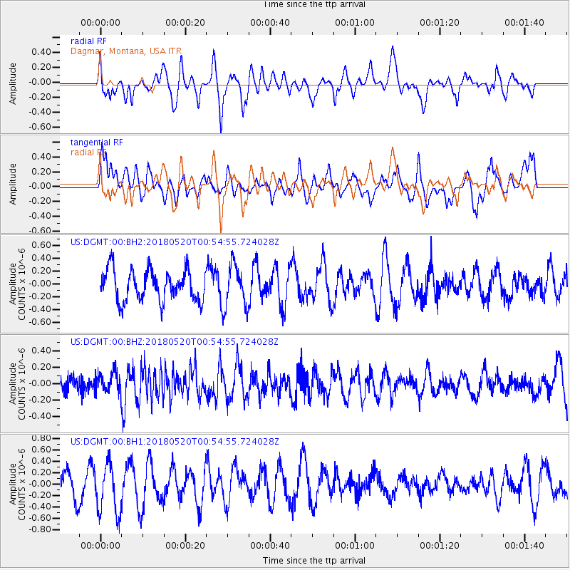
DGMT Dagmar, Montana, USA - Earthquake Result Viewer
*The percent match for this event was below the threshold and hence no stack was calculated.
| Earthquake location: |
Tonga Islands |
| Earthquake latitude/longitude: |
-21.0/-174.0 |
| Earthquake time(UTC): |
2018/05/20 (140) 00:42:14 GMT |
| Earthquake Depth: |
10 km |
| Earthquake Magnitude: |
5.5 Mww |
| Earthquake Catalog/Contributor: |
NEIC PDE/us |
|
| Network: |
US United States National Seismic Network |
| Station: |
DGMT Dagmar, Montana, USA |
| Lat/Lon: |
48.47 N/104.20 W |
| Elevation: |
0.0 m |
|
| Distance: |
92.9 deg |
| Az: |
38.712 deg |
| Baz: |
241.43 deg |
| Ray Param: |
$rayparam |
*The percent match for this event was below the threshold and hence was not used in the summary stack. |
|
| Radial Match: |
44.81232 % |
| Radial Bump: |
400 |
| Transverse Match: |
61.647446 % |
| Transverse Bump: |
400 |
| SOD ConfigId: |
2665671 |
| Insert Time: |
2018-06-03 00:53:55.261 +0000 |
| GWidth: |
2.5 |
| Max Bumps: |
400 |
| Tol: |
0.001 |
|
Signal To Noise
| Channel | StoN | STA | LTA |
| US:DGMT:00:BHZ:20180520T00:54:55.724028Z | 0.90969926 | 1.1805862E-7 | 1.2977763E-7 |
| US:DGMT:00:BH1:20180520T00:54:55.724028Z | 2.2878795 | 4.587441E-7 | 2.0051058E-7 |
| US:DGMT:00:BH2:20180520T00:54:55.724028Z | 1.3826005 | 3.354586E-7 | 2.4262872E-7 |
| Arrivals |
| Ps | |
| PpPs | |
| PsPs/PpSs | |


