You are here: Home > Network List > II - Global Seismograph Network (GSN - IRIS/IDA) Stations List
> Station XPFO Pinon Flat, California, USA > Earthquake Result Viewer
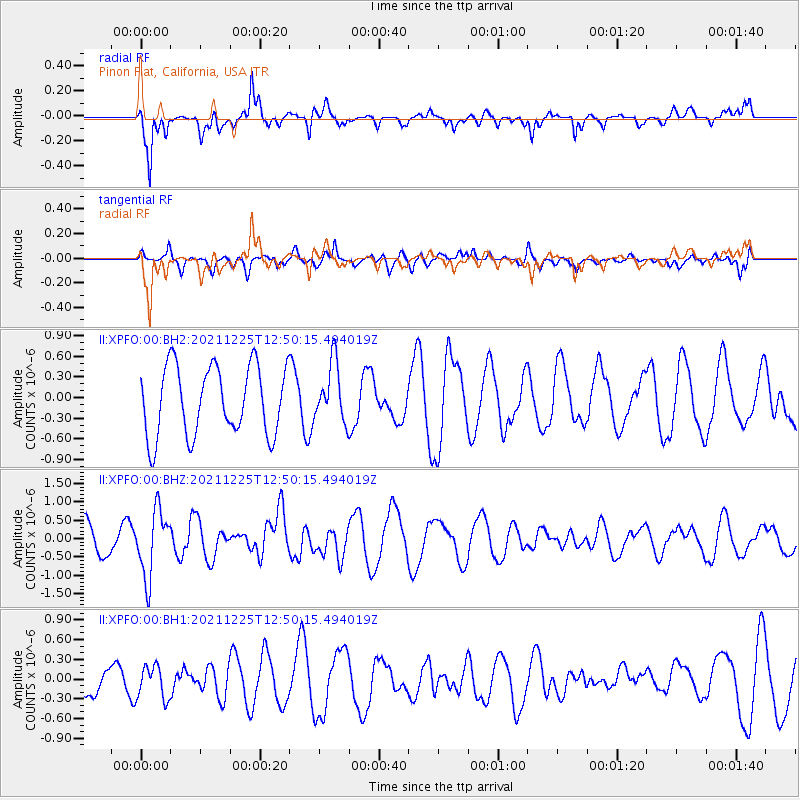
XPFO Pinon Flat, California, USA - Earthquake Result Viewer
*The percent match for this event was below the threshold and hence no stack was calculated.
| Earthquake location: |
Tonga Islands |
| Earthquake latitude/longitude: |
-17.1/-173.6 |
| Earthquake time(UTC): |
2021/12/25 (359) 12:39:21 GMT |
| Earthquake Depth: |
105 km |
| Earthquake Magnitude: |
6.0 Mi |
| Earthquake Catalog/Contributor: |
NEIC PDE/pt |
|
| Network: |
II Global Seismograph Network (GSN - IRIS/IDA) |
| Station: |
XPFO Pinon Flat, California, USA |
| Lat/Lon: |
33.61 N/116.46 W |
| Elevation: |
1280 m |
|
| Distance: |
74.2 deg |
| Az: |
46.772 deg |
| Baz: |
236.622 deg |
| Ray Param: |
$rayparam |
*The percent match for this event was below the threshold and hence was not used in the summary stack. |
|
| Radial Match: |
76.20238 % |
| Radial Bump: |
400 |
| Transverse Match: |
51.01888 % |
| Transverse Bump: |
400 |
| SOD ConfigId: |
26694651 |
| Insert Time: |
2022-01-08 12:51:03.173 +0000 |
| GWidth: |
2.5 |
| Max Bumps: |
400 |
| Tol: |
0.001 |
|
Signal To Noise
| Channel | StoN | STA | LTA |
| II:XPFO:00:BHZ:20211225T12:50:15.494019Z | 1.8332524 | 8.994134E-7 | 4.906108E-7 |
| II:XPFO:00:BH1:20211225T12:50:15.494019Z | 1.4837277 | 2.5127235E-7 | 1.6935206E-7 |
| II:XPFO:00:BH2:20211225T12:50:15.494019Z | 0.8477932 | 4.2613902E-7 | 5.02645E-7 |
| Arrivals |
| Ps | |
| PpPs | |
| PsPs/PpSs | |


