You are here: Home > Network List > XE05 - Sierra Nevada EarthScope Project- EarthScope Flex Array Stations List
> Station SNP26 SNP26 > Earthquake Result Viewer
SNP26 SNP26 - Earthquake Result Viewer
| Earthquake location: |
Southern Peru |
| Earthquake latitude/longitude: |
-15.3/-73.0 |
| Earthquake time(UTC): |
2005/07/26 (207) 14:11:36 GMT |
| Earthquake Depth: |
110 km |
| Earthquake Magnitude: |
5.8 MB, 6.0 MW, 5.9 MW |
| Earthquake Catalog/Contributor: |
WHDF/NEIC |
|
| Network: |
XE Sierra Nevada EarthScope Project- EarthScope Flex Array |
| Station: |
SNP26 SNP26 |
| Lat/Lon: |
37.57 N/118.49 W |
| Elevation: |
1680 m |
|
| Distance: |
67.8 deg |
| Az: |
322.248 deg |
| Baz: |
131.977 deg |
| Ray Param: |
0.056415297 |
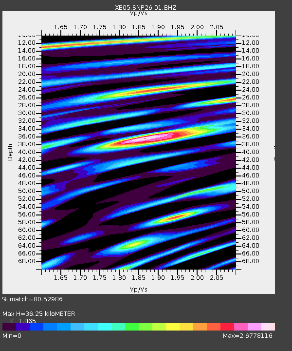
| Estimated Moho Depth: |
36.25 km |
| Estimated Crust Vp/Vs: |
1.87 |
| Assumed Crust Vp: |
6.291 km/s |
| Estimated Crust Vs: |
3.373 km/s |
| Estimated Crust Poisson's Ratio: |
0.30 |
|
| Radial Match: |
80.52986 % |
| Radial Bump: |
400 |
| Transverse Match: |
78.26608 % |
| Transverse Bump: |
400 |
| SOD ConfigId: |
268666 |
| Insert Time: |
2010-03-09 15:14:45.300 +0000 |
| GWidth: |
2.5 |
| Max Bumps: |
400 |
| Tol: |
0.001 |
|

Signal To Noise
| Channel | StoN | STA | LTA |
| XE:SNP26:01:BHZ:20050726T14:21:51.814011Z | 7.703899 | 1.035571E-6 | 1.3442168E-7 |
| XE:SNP26:01:BHN:20050726T14:21:51.814011Z | 3.6661584 | 6.3683666E-7 | 1.737068E-7 |
| XE:SNP26:01:BHE:20050726T14:21:51.814011Z | 2.331134 | 4.7368425E-7 | 2.0319906E-7 |
| Arrivals |
| Ps | 5.2 SECOND |
| PpPs | 16 SECOND |
| PsPs/PpSs | 21 SECOND |


