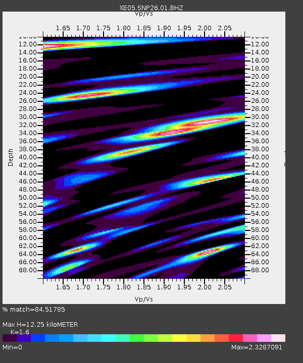
SNP26 SNP26 - Earthquake Result Viewer

Earthquake location: Kermadec Islands, New Zealand
Earthquake latitude/longitude: -30.0/-177.6
Earthquake time(UTC): 2005/12/07 (341) 23:32:51 GMT
Earthquake Depth: 21 km
Earthquake Magnitude: 6.0 MB, 6.4 MS, 6.4 MW, 6.3 MW
Earthquake Catalog/Contributor: WHDF/NEIC
Network: XE Sierra Nevada EarthScope Project- EarthScope Flex Array
Station: SNP26 SNP26
Lat/Lon: 37.57 N/118.49 W
Elevation: 1680 m
Distance: 87.1 deg
Az: 43.081 deg
Baz: 228.213 deg
Ray Param: 0.043575905
Estimated Moho Depth: 12.25 km
Estimated Crust Vp/Vs: 1.60
Assumed Crust Vp: 6.291 km/s
Estimated Crust Vs: 3.932 km/s
Estimated Crust Poisson's Ratio: 0.18
Radial Match: 84.51785 %
Radial Bump: 400
Transverse Match: 87.22357 %
Transverse Bump: 400
SOD ConfigId: 268666
Insert Time: 2010-03-09 15:14:58.601 +0000
GWidth: 2.5
Max Bumps: 400
Tol: 0.001

Signal To Noise

ChannelStoNSTALTA
XE:SNP26:01:BHZ:20051207T23:45:04.023999Z8.1227851.6467403E-62.02731E-7
XE:SNP26:01:BHN:20051207T23:45:04.023999Z2.12190375.729215E-72.7000354E-7
XE:SNP26:01:BHE:20051207T23:45:04.023999Z1.47968224.0457667E-72.734213E-7
Arrivals
Ps1.2 SECOND
PpPs4.9 SECOND
PsPs/PpSs6.1 SECOND