You are here: Home > Network List > US - United States National Seismic Network Stations List
> Station AMTX Amarillo, Texas, USA > Earthquake Result Viewer
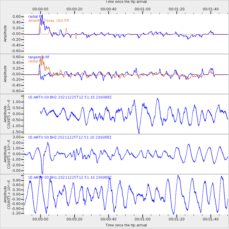
AMTX Amarillo, Texas, USA - Earthquake Result Viewer
*The percent match for this event was below the threshold and hence no stack was calculated.
| Earthquake location: |
Tonga Islands |
| Earthquake latitude/longitude: |
-17.1/-173.6 |
| Earthquake time(UTC): |
2021/12/25 (359) 12:39:21 GMT |
| Earthquake Depth: |
105 km |
| Earthquake Magnitude: |
6.0 Mi |
| Earthquake Catalog/Contributor: |
NEIC PDE/pt |
|
| Network: |
US United States National Seismic Network |
| Station: |
AMTX Amarillo, Texas, USA |
| Lat/Lon: |
34.53 N/101.41 W |
| Elevation: |
1010 m |
|
| Distance: |
85.6 deg |
| Az: |
52.039 deg |
| Baz: |
245.973 deg |
| Ray Param: |
$rayparam |
*The percent match for this event was below the threshold and hence was not used in the summary stack. |
|
| Radial Match: |
68.34545 % |
| Radial Bump: |
400 |
| Transverse Match: |
60.805153 % |
| Transverse Bump: |
400 |
| SOD ConfigId: |
26694651 |
| Insert Time: |
2022-01-08 12:59:02.484 +0000 |
| GWidth: |
2.5 |
| Max Bumps: |
400 |
| Tol: |
0.001 |
|
Signal To Noise
| Channel | StoN | STA | LTA |
| US:AMTX:00:BHZ:20211225T12:51:16.299988Z | 3.795966 | 1.5929073E-6 | 4.1963162E-7 |
| US:AMTX:00:BH1:20211225T12:51:16.299988Z | 1.0891621 | 7.834404E-7 | 7.193056E-7 |
| US:AMTX:00:BH2:20211225T12:51:16.299988Z | 1.1144776 | 3.1890818E-7 | 2.8615037E-7 |
| Arrivals |
| Ps | |
| PpPs | |
| PsPs/PpSs | |


