You are here: Home > Network List > UW - Pacific Northwest Regional Seismic Network Stations List
> Station IRON Crane, OR, USA > Earthquake Result Viewer
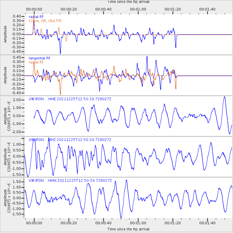
IRON Crane, OR, USA - Earthquake Result Viewer
*The percent match for this event was below the threshold and hence no stack was calculated.
| Earthquake location: |
Tonga Islands |
| Earthquake latitude/longitude: |
-17.1/-173.6 |
| Earthquake time(UTC): |
2021/12/25 (359) 12:39:21 GMT |
| Earthquake Depth: |
105 km |
| Earthquake Magnitude: |
6.0 Mi |
| Earthquake Catalog/Contributor: |
NEIC PDE/pt |
|
| Network: |
UW Pacific Northwest Regional Seismic Network |
| Station: |
IRON Crane, OR, USA |
| Lat/Lon: |
43.36 N/118.47 W |
| Elevation: |
1226 m |
|
| Distance: |
78.5 deg |
| Az: |
37.642 deg |
| Baz: |
233.209 deg |
| Ray Param: |
$rayparam |
*The percent match for this event was below the threshold and hence was not used in the summary stack. |
|
| Radial Match: |
71.47072 % |
| Radial Bump: |
312 |
| Transverse Match: |
75.93464 % |
| Transverse Bump: |
360 |
| SOD ConfigId: |
26694651 |
| Insert Time: |
2022-01-08 12:59:53.557 +0000 |
| GWidth: |
2.5 |
| Max Bumps: |
400 |
| Tol: |
0.001 |
|
Signal To Noise
| Channel | StoN | STA | LTA |
| UW:IRON: :HHZ:20211225T12:50:39.728027Z | 1.1747016 | 8.6647646E-7 | 7.3761413E-7 |
| UW:IRON: :HHN:20211225T12:50:39.728027Z | 1.0027059 | 4.768815E-7 | 4.7559453E-7 |
| UW:IRON: :HHE:20211225T12:50:39.728027Z | 2.209184 | 1.1279561E-6 | 5.1057594E-7 |
| Arrivals |
| Ps | |
| PpPs | |
| PsPs/PpSs | |


