You are here: Home > Network List > CN - Canadian National Seismograph Network Stations List
> Station ATKO Atikokan Iron Mine, ON, CA > Earthquake Result Viewer
ATKO Atikokan Iron Mine, ON, CA - Earthquake Result Viewer
| Earthquake location: |
Tonga Islands |
| Earthquake latitude/longitude: |
-17.0/-173.5 |
| Earthquake time(UTC): |
2021/12/25 (359) 12:39:09 GMT |
| Earthquake Depth: |
8.6 km |
| Earthquake Magnitude: |
5.9 mb |
| Earthquake Catalog/Contributor: |
NEIC PDE/us |
|
| Network: |
CN Canadian National Seismograph Network |
| Station: |
ATKO Atikokan Iron Mine, ON, CA |
| Lat/Lon: |
48.82 N/91.60 W |
| Elevation: |
383 m |
|
| Distance: |
97.4 deg |
| Az: |
41.289 deg |
| Baz: |
252.797 deg |
| Ray Param: |
0.0402204 |
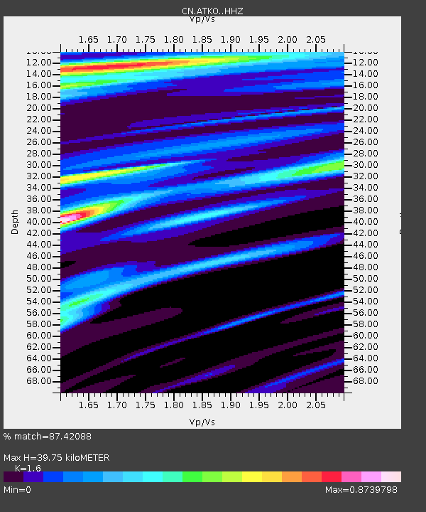
| Estimated Moho Depth: |
39.75 km |
| Estimated Crust Vp/Vs: |
1.60 |
| Assumed Crust Vp: |
6.467 km/s |
| Estimated Crust Vs: |
4.042 km/s |
| Estimated Crust Poisson's Ratio: |
0.18 |
|
| Radial Match: |
87.42088 % |
| Radial Bump: |
400 |
| Transverse Match: |
66.78864 % |
| Transverse Bump: |
400 |
| SOD ConfigId: |
26694651 |
| Insert Time: |
2022-01-08 13:09:13.002 +0000 |
| GWidth: |
2.5 |
| Max Bumps: |
400 |
| Tol: |
0.001 |
|

Signal To Noise
| Channel | StoN | STA | LTA |
| CN:ATKO: :HHZ:20211225T12:52:11.279974Z | 2.4059007 | 1.9168322E-6 | 7.967212E-7 |
| CN:ATKO: :HHN:20211225T12:52:11.279974Z | 1.318657 | 7.1722246E-7 | 5.439037E-7 |
| CN:ATKO: :HHE:20211225T12:52:11.279974Z | 2.182748 | 1.1671858E-6 | 5.3473224E-7 |
| Arrivals |
| Ps | 3.8 SECOND |
| PpPs | 16 SECOND |
| PsPs/PpSs | 19 SECOND |


