You are here: Home > Network List > UW - Pacific Northwest Regional Seismic Network Stations List
> Station IRON Crane, OR, USA > Earthquake Result Viewer
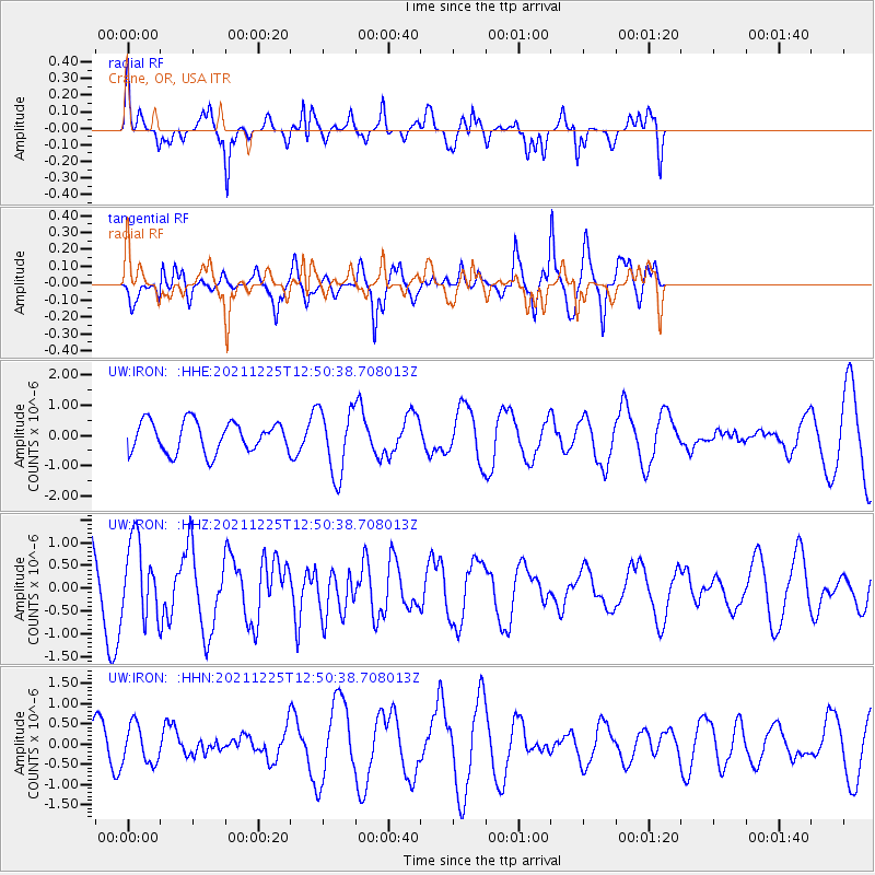
IRON Crane, OR, USA - Earthquake Result Viewer
*The percent match for this event was below the threshold and hence no stack was calculated.
| Earthquake location: |
Tonga Islands |
| Earthquake latitude/longitude: |
-17.0/-173.5 |
| Earthquake time(UTC): |
2021/12/25 (359) 12:39:09 GMT |
| Earthquake Depth: |
8.6 km |
| Earthquake Magnitude: |
5.9 mb |
| Earthquake Catalog/Contributor: |
NEIC PDE/us |
|
| Network: |
UW Pacific Northwest Regional Seismic Network |
| Station: |
IRON Crane, OR, USA |
| Lat/Lon: |
43.36 N/118.47 W |
| Elevation: |
1226 m |
|
| Distance: |
78.4 deg |
| Az: |
37.603 deg |
| Baz: |
233.169 deg |
| Ray Param: |
$rayparam |
*The percent match for this event was below the threshold and hence was not used in the summary stack. |
|
| Radial Match: |
72.36243 % |
| Radial Bump: |
320 |
| Transverse Match: |
74.83123 % |
| Transverse Bump: |
337 |
| SOD ConfigId: |
26694651 |
| Insert Time: |
2022-01-08 13:20:17.578 +0000 |
| GWidth: |
2.5 |
| Max Bumps: |
400 |
| Tol: |
0.001 |
|
Signal To Noise
| Channel | StoN | STA | LTA |
| UW:IRON: :HHZ:20211225T12:50:38.708013Z | 1.1290145 | 8.284512E-7 | 7.3378266E-7 |
| UW:IRON: :HHN:20211225T12:50:38.708013Z | 0.9901313 | 4.7182235E-7 | 4.7652503E-7 |
| UW:IRON: :HHE:20211225T12:50:38.708013Z | 2.1426156 | 1.0842311E-6 | 5.0603154E-7 |
| Arrivals |
| Ps | |
| PpPs | |
| PsPs/PpSs | |


