You are here: Home > Network List > AV - Alaska Volcano Observatory Stations List
> Station PLBL Mt. Peulik Volcano, Alaska > Earthquake Result Viewer
PLBL Mt. Peulik Volcano, Alaska - Earthquake Result Viewer
*The percent match for this event was below the threshold and hence no stack was calculated.
| Earthquake location: |
Southwestern Ryukyu Isl., Japan |
| Earthquake latitude/longitude: |
25.2/125.6 |
| Earthquake time(UTC): |
2021/12/26 (360) 08:26:46 GMT |
| Earthquake Depth: |
10 km |
| Earthquake Magnitude: |
5.9 mww |
| Earthquake Catalog/Contributor: |
NEIC PDE/us |
|
| Network: |
AV Alaska Volcano Observatory |
| Station: |
PLBL Mt. Peulik Volcano, Alaska |
| Lat/Lon: |
57.70 N/156.82 W |
| Elevation: |
461 m |
|
| Distance: |
62.5 deg |
| Az: |
36.249 deg |
| Baz: |
274.095 deg |
| Ray Param: |
$rayparam |
*The percent match for this event was below the threshold and hence was not used in the summary stack. |
|
| Radial Match: |
77.79472 % |
| Radial Bump: |
400 |
| Transverse Match: |
54.29999 % |
| Transverse Bump: |
400 |
| SOD ConfigId: |
26694651 |
| Insert Time: |
2022-01-09 08:33:28.896 +0000 |
| GWidth: |
2.5 |
| Max Bumps: |
400 |
| Tol: |
0.001 |
|
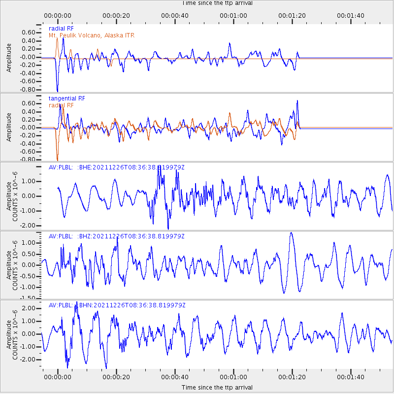
Signal To Noise
| Channel | StoN | STA | LTA |
| AV:PLBL: :BHZ:20211226T08:36:38.819979Z | 1.0646478 | 3.2413493E-7 | 3.0445275E-7 |
| AV:PLBL: :BHN:20211226T08:36:38.819979Z | 2.5140464 | 1.1493316E-6 | 4.5716402E-7 |
| AV:PLBL: :BHE:20211226T08:36:38.819979Z | 1.414267 | 8.295771E-7 | 5.8657747E-7 |
| Arrivals |
| Ps | |
| PpPs | |
| PsPs/PpSs | |


