You are here: Home > Network List > C8 - Canadian Seismic Research Network () Stations List
> Station GRIB Gribbell Island, BC, CA > Earthquake Result Viewer
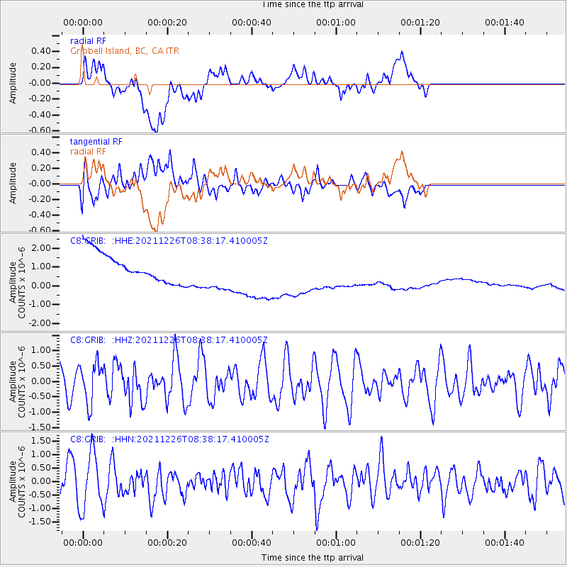
GRIB Gribbell Island, BC, CA - Earthquake Result Viewer
*The percent match for this event was below the threshold and hence no stack was calculated.
| Earthquake location: |
Southwestern Ryukyu Isl., Japan |
| Earthquake latitude/longitude: |
25.2/125.6 |
| Earthquake time(UTC): |
2021/12/26 (360) 08:26:46 GMT |
| Earthquake Depth: |
10 km |
| Earthquake Magnitude: |
5.9 mww |
| Earthquake Catalog/Contributor: |
NEIC PDE/us |
|
| Network: |
C8 Canadian Seismic Research Network () |
| Station: |
GRIB Gribbell Island, BC, CA |
| Lat/Lon: |
53.34 N/129.14 W |
| Elevation: |
418 m |
|
| Distance: |
78.7 deg |
| Az: |
36.154 deg |
| Baz: |
296.993 deg |
| Ray Param: |
$rayparam |
*The percent match for this event was below the threshold and hence was not used in the summary stack. |
|
| Radial Match: |
13.629789 % |
| Radial Bump: |
400 |
| Transverse Match: |
32.315506 % |
| Transverse Bump: |
400 |
| SOD ConfigId: |
26694651 |
| Insert Time: |
2022-01-09 08:34:53.877 +0000 |
| GWidth: |
2.5 |
| Max Bumps: |
400 |
| Tol: |
0.001 |
|
Signal To Noise
| Channel | StoN | STA | LTA |
| C8:GRIB: :HHZ:20211226T08:38:17.410005Z | 1.7923548 | 6.5338503E-7 | 3.6454E-7 |
| C8:GRIB: :HHN:20211226T08:38:17.410005Z | 1.6248657 | 1.0557484E-6 | 6.49745E-7 |
| C8:GRIB: :HHE:20211226T08:38:17.410005Z | 1.4004697 | 1.0739401E-6 | 7.668428E-7 |
| Arrivals |
| Ps | |
| PpPs | |
| PsPs/PpSs | |


