You are here: Home > Network List > CN - Canadian National Seismograph Network Stations List
> Station INK INUVIK, NT > Earthquake Result Viewer
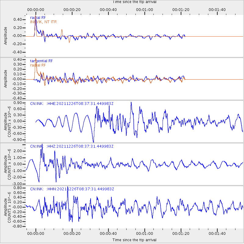
INK INUVIK, NT - Earthquake Result Viewer
*The percent match for this event was below the threshold and hence no stack was calculated.
| Earthquake location: |
Southwestern Ryukyu Isl., Japan |
| Earthquake latitude/longitude: |
25.2/125.6 |
| Earthquake time(UTC): |
2021/12/26 (360) 08:26:46 GMT |
| Earthquake Depth: |
10 km |
| Earthquake Magnitude: |
5.9 mww |
| Earthquake Catalog/Contributor: |
NEIC PDE/us |
|
| Network: |
CN Canadian National Seismograph Network |
| Station: |
INK INUVIK, NT |
| Lat/Lon: |
68.31 N/133.53 W |
| Elevation: |
44 m |
|
| Distance: |
70.7 deg |
| Az: |
22.753 deg |
| Baz: |
289.578 deg |
| Ray Param: |
$rayparam |
*The percent match for this event was below the threshold and hence was not used in the summary stack. |
|
| Radial Match: |
70.068214 % |
| Radial Bump: |
400 |
| Transverse Match: |
54.282593 % |
| Transverse Bump: |
400 |
| SOD ConfigId: |
26694651 |
| Insert Time: |
2022-01-09 08:37:26.304 +0000 |
| GWidth: |
2.5 |
| Max Bumps: |
400 |
| Tol: |
0.001 |
|
Signal To Noise
| Channel | StoN | STA | LTA |
| CN:INK: :HHZ:20211226T08:37:31.449983Z | 4.933951 | 1.5259934E-6 | 3.0928427E-7 |
| CN:INK: :HHN:20211226T08:37:31.449983Z | 0.92819273 | 1.8787067E-7 | 2.024048E-7 |
| CN:INK: :HHE:20211226T08:37:31.449983Z | 2.269449 | 4.8911426E-7 | 2.1552115E-7 |
| Arrivals |
| Ps | |
| PpPs | |
| PsPs/PpSs | |


