You are here: Home > Network List > IW - Intermountain West Stations List
> Station MOOW Moose Ponds, Wyoming, USA > Earthquake Result Viewer
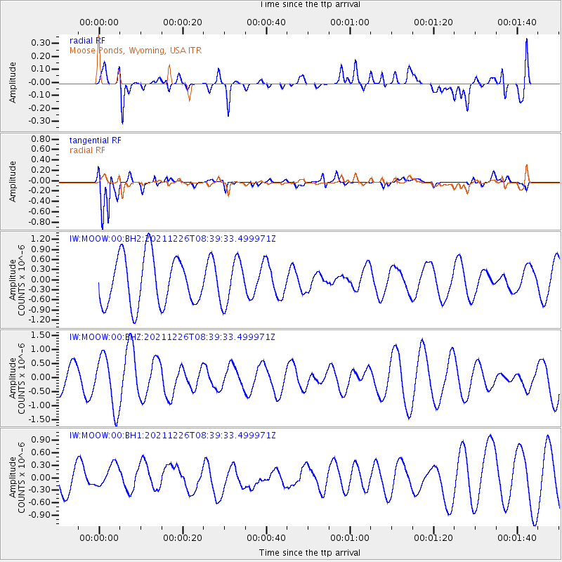
MOOW Moose Ponds, Wyoming, USA - Earthquake Result Viewer
*The percent match for this event was below the threshold and hence no stack was calculated.
| Earthquake location: |
Southwestern Ryukyu Isl., Japan |
| Earthquake latitude/longitude: |
25.2/125.6 |
| Earthquake time(UTC): |
2021/12/26 (360) 08:26:46 GMT |
| Earthquake Depth: |
10 km |
| Earthquake Magnitude: |
5.9 mww |
| Earthquake Catalog/Contributor: |
NEIC PDE/us |
|
| Network: |
IW Intermountain West |
| Station: |
MOOW Moose Ponds, Wyoming, USA |
| Lat/Lon: |
43.75 N/110.74 W |
| Elevation: |
2128 m |
|
| Distance: |
94.1 deg |
| Az: |
37.209 deg |
| Baz: |
310.905 deg |
| Ray Param: |
$rayparam |
*The percent match for this event was below the threshold and hence was not used in the summary stack. |
|
| Radial Match: |
61.595688 % |
| Radial Bump: |
400 |
| Transverse Match: |
81.715965 % |
| Transverse Bump: |
400 |
| SOD ConfigId: |
26694651 |
| Insert Time: |
2022-01-09 08:40:43.140 +0000 |
| GWidth: |
2.5 |
| Max Bumps: |
400 |
| Tol: |
0.001 |
|
Signal To Noise
| Channel | StoN | STA | LTA |
| IW:MOOW:00:BHZ:20211226T08:39:33.499971Z | 2.54578 | 9.645718E-7 | 3.7889046E-7 |
| IW:MOOW:00:BH1:20211226T08:39:33.499971Z | 0.974288 | 2.9656763E-7 | 3.0439423E-7 |
| IW:MOOW:00:BH2:20211226T08:39:33.499971Z | 0.8967325 | 6.53578E-7 | 7.288439E-7 |
| Arrivals |
| Ps | |
| PpPs | |
| PsPs/PpSs | |


