You are here: Home > Network List > XE05 - Sierra Nevada EarthScope Project- EarthScope Flex Array Stations List
> Station SNP27 SNP27 > Earthquake Result Viewer
SNP27 SNP27 - Earthquake Result Viewer
| Earthquake location: |
New Ireland Region, P.N.G. |
| Earthquake latitude/longitude: |
-4.5/153.5 |
| Earthquake time(UTC): |
2005/09/09 (252) 07:26:43 GMT |
| Earthquake Depth: |
90 km |
| Earthquake Magnitude: |
6.3 MB, 7.7 MW, 7.5 MW |
| Earthquake Catalog/Contributor: |
WHDF/NEIC |
|
| Network: |
XE Sierra Nevada EarthScope Project- EarthScope Flex Array |
| Station: |
SNP27 SNP27 |
| Lat/Lon: |
37.66 N/118.35 W |
| Elevation: |
1739 m |
|
| Distance: |
91.3 deg |
| Az: |
52.507 deg |
| Baz: |
265.312 deg |
| Ray Param: |
0.041594855 |
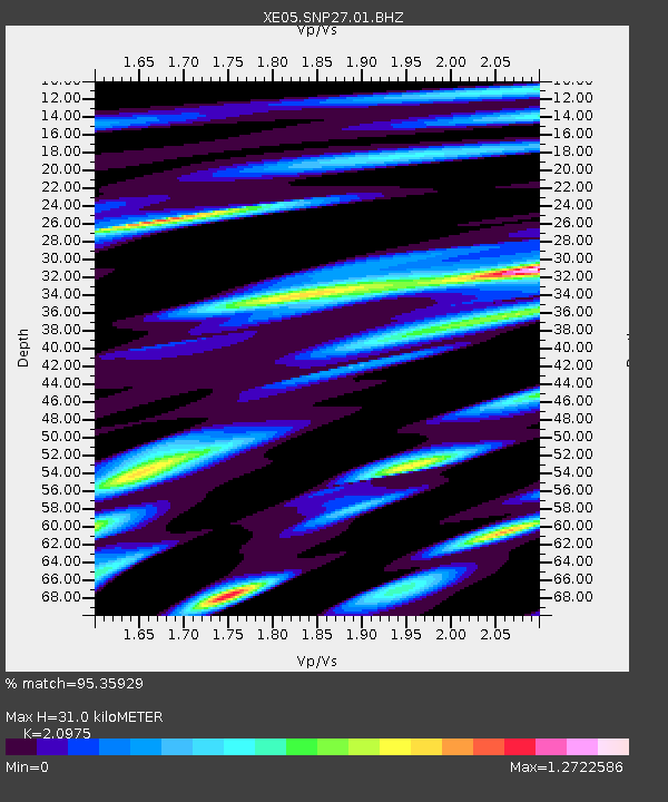
| Estimated Moho Depth: |
31.0 km |
| Estimated Crust Vp/Vs: |
2.10 |
| Assumed Crust Vp: |
6.291 km/s |
| Estimated Crust Vs: |
2.999 km/s |
| Estimated Crust Poisson's Ratio: |
0.35 |
|
| Radial Match: |
95.35929 % |
| Radial Bump: |
400 |
| Transverse Match: |
84.7432 % |
| Transverse Bump: |
400 |
| SOD ConfigId: |
268666 |
| Insert Time: |
2010-03-09 15:18:13.355 +0000 |
| GWidth: |
2.5 |
| Max Bumps: |
400 |
| Tol: |
0.001 |
|

Signal To Noise
| Channel | StoN | STA | LTA |
| XE:SNP27:01:BHZ:20050909T07:39:07.969014Z | 12.760643 | 9.0734085E-7 | 7.110463E-8 |
| XE:SNP27:01:BHN:20050909T07:39:07.969014Z | 0.8215033 | 7.924795E-8 | 9.646699E-8 |
| XE:SNP27:01:BHE:20050909T07:39:07.969014Z | 2.633595 | 2.3942823E-7 | 9.091308E-8 |
| Arrivals |
| Ps | 5.5 SECOND |
| PpPs | 15 SECOND |
| PsPs/PpSs | 21 SECOND |


