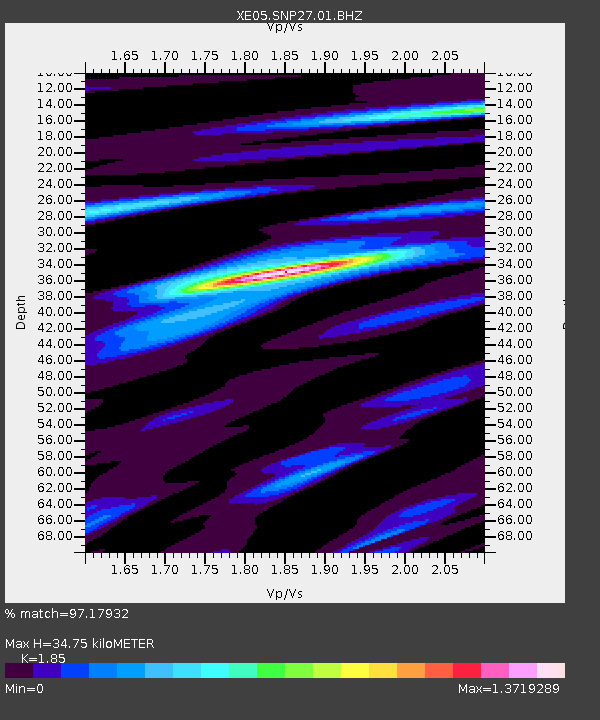
SNP27 SNP27 - Earthquake Result Viewer

Earthquake location: Tonga Islands
Earthquake latitude/longitude: -20.2/-174.1
Earthquake time(UTC): 2006/05/03 (123) 15:26:40 GMT
Earthquake Depth: 55 km
Earthquake Magnitude: 7.2 MB, 7.8 MS, 7.9 MW, 7.9 MW
Earthquake Catalog/Contributor: WHDF/NEIC
Network: XE Sierra Nevada EarthScope Project- EarthScope Flex Array
Station: SNP27 SNP27
Lat/Lon: 37.66 N/118.35 W
Elevation: 1739 m
Distance: 77.8 deg
Az: 42.162 deg
Baz: 232.603 deg
Ray Param: 0.049942702
Estimated Moho Depth: 34.75 km
Estimated Crust Vp/Vs: 1.85
Assumed Crust Vp: 6.291 km/s
Estimated Crust Vs: 3.401 km/s
Estimated Crust Poisson's Ratio: 0.29
Radial Match: 97.17932 %
Radial Bump: 400
Transverse Match: 89.18514 %
Transverse Bump: 400
SOD ConfigId: 268666
Insert Time: 2010-03-09 15:18:56.134 +0000
GWidth: 2.5
Max Bumps: 400
Tol: 0.001

Signal To Noise

ChannelStoNSTALTA
XE:SNP27:01:BHZ:20060503T15:38:00.93502Z5.1548941.9090962E-63.7034636E-7
XE:SNP27:01:BHN:20060503T15:38:00.93502Z2.37492135.4445707E-72.2925268E-7
XE:SNP27:01:BHE:20060503T15:38:00.93502Z3.8227018.209857E-72.1476588E-7
Arrivals
Ps4.8 SECOND
PpPs15 SECOND
PsPs/PpSs20 SECOND