You are here: Home > Network List > AV - Alaska Volcano Observatory Stations List
> Station AMKA Regional Station, Amchitka Island, Alaska > Earthquake Result Viewer
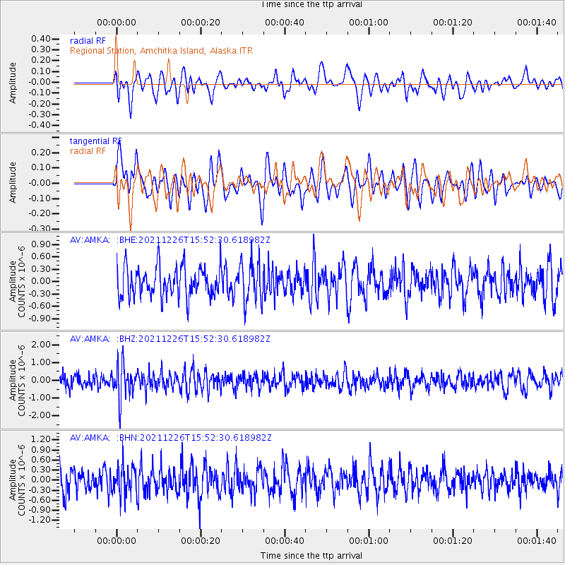
AMKA Regional Station, Amchitka Island, Alaska - Earthquake Result Viewer
*The percent match for this event was below the threshold and hence no stack was calculated.
| Earthquake location: |
Fiji Islands Region |
| Earthquake latitude/longitude: |
-18.1/-179.4 |
| Earthquake time(UTC): |
2021/12/26 (360) 15:42:56 GMT |
| Earthquake Depth: |
627 km |
| Earthquake Magnitude: |
6.1 mww |
| Earthquake Catalog/Contributor: |
NEIC PDE/us |
|
| Network: |
AV Alaska Volcano Observatory |
| Station: |
AMKA Regional Station, Amchitka Island, Alaska |
| Lat/Lon: |
51.38 N/179.30 E |
| Elevation: |
116 m |
|
| Distance: |
69.2 deg |
| Az: |
359.103 deg |
| Baz: |
178.639 deg |
| Ray Param: |
$rayparam |
*The percent match for this event was below the threshold and hence was not used in the summary stack. |
|
| Radial Match: |
47.25445 % |
| Radial Bump: |
400 |
| Transverse Match: |
47.644253 % |
| Transverse Bump: |
400 |
| SOD ConfigId: |
26694651 |
| Insert Time: |
2022-01-09 15:49:28.126 +0000 |
| GWidth: |
2.5 |
| Max Bumps: |
400 |
| Tol: |
0.001 |
|
Signal To Noise
| Channel | StoN | STA | LTA |
| AV:AMKA: :BHZ:20211226T15:52:30.618982Z | 2.4372468 | 9.506166E-7 | 3.900371E-7 |
| AV:AMKA: :BHN:20211226T15:52:30.618982Z | 1.1923629 | 4.3551134E-7 | 3.6525066E-7 |
| AV:AMKA: :BHE:20211226T15:52:30.618982Z | 1.407645 | 5.0178215E-7 | 3.564693E-7 |
| Arrivals |
| Ps | |
| PpPs | |
| PsPs/PpSs | |


