You are here: Home > Network List > XE05 - Sierra Nevada EarthScope Project- EarthScope Flex Array Stations List
> Station SNP27 SNP27 > Earthquake Result Viewer
SNP27 SNP27 - Earthquake Result Viewer
| Earthquake location: |
Fiji Islands Region |
| Earthquake latitude/longitude: |
-20.8/-178.7 |
| Earthquake time(UTC): |
2006/06/02 (153) 07:31:36 GMT |
| Earthquake Depth: |
592 km |
| Earthquake Magnitude: |
5.5 MB, 6.0 MW, 6.0 MW |
| Earthquake Catalog/Contributor: |
WHDF/NEIC |
|
| Network: |
XE Sierra Nevada EarthScope Project- EarthScope Flex Array |
| Station: |
SNP27 SNP27 |
| Lat/Lon: |
37.66 N/118.35 W |
| Elevation: |
1739 m |
|
| Distance: |
81.3 deg |
| Az: |
44.253 deg |
| Baz: |
235.333 deg |
| Ray Param: |
0.04591279 |
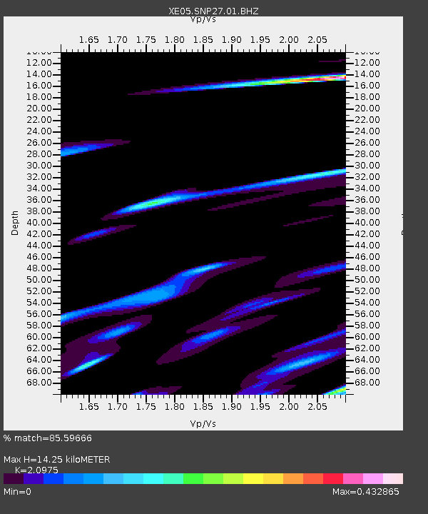
| Estimated Moho Depth: |
14.25 km |
| Estimated Crust Vp/Vs: |
2.10 |
| Assumed Crust Vp: |
6.291 km/s |
| Estimated Crust Vs: |
2.999 km/s |
| Estimated Crust Poisson's Ratio: |
0.35 |
|
| Radial Match: |
85.59666 % |
| Radial Bump: |
400 |
| Transverse Match: |
71.78429 % |
| Transverse Bump: |
400 |
| SOD ConfigId: |
268666 |
| Insert Time: |
2010-03-09 15:19:05.341 +0000 |
| GWidth: |
2.5 |
| Max Bumps: |
400 |
| Tol: |
0.001 |
|

Signal To Noise
| Channel | StoN | STA | LTA |
| XE:SNP27:01:BHZ:20060602T07:42:20.558999Z | 2.5102022 | 3.6923126E-7 | 1.4709224E-7 |
| XE:SNP27:01:BHN:20060602T07:42:20.558999Z | 1.6735411 | 1.19176754E-7 | 7.121233E-8 |
| XE:SNP27:01:BHE:20060602T07:42:20.558999Z | 1.760099 | 1.9832788E-7 | 1.12679956E-7 |
| Arrivals |
| Ps | 2.5 SECOND |
| PpPs | 6.9 SECOND |
| PsPs/PpSs | 9.4 SECOND |


