You are here: Home > Network List > US - United States National Seismic Network Stations List
> Station AMTX Amarillo, Texas, USA > Earthquake Result Viewer
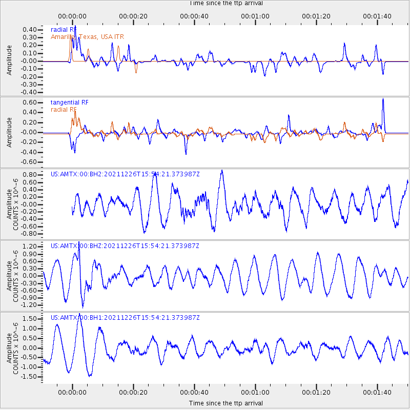
AMTX Amarillo, Texas, USA - Earthquake Result Viewer
*The percent match for this event was below the threshold and hence no stack was calculated.
| Earthquake location: |
Fiji Islands Region |
| Earthquake latitude/longitude: |
-18.1/-179.4 |
| Earthquake time(UTC): |
2021/12/26 (360) 15:42:56 GMT |
| Earthquake Depth: |
627 km |
| Earthquake Magnitude: |
6.1 mww |
| Earthquake Catalog/Contributor: |
NEIC PDE/us |
|
| Network: |
US United States National Seismic Network |
| Station: |
AMTX Amarillo, Texas, USA |
| Lat/Lon: |
34.53 N/101.41 W |
| Elevation: |
1010 m |
|
| Distance: |
90.6 deg |
| Az: |
53.848 deg |
| Baz: |
248.486 deg |
| Ray Param: |
$rayparam |
*The percent match for this event was below the threshold and hence was not used in the summary stack. |
|
| Radial Match: |
64.41547 % |
| Radial Bump: |
400 |
| Transverse Match: |
50.224754 % |
| Transverse Bump: |
388 |
| SOD ConfigId: |
26694651 |
| Insert Time: |
2022-01-09 16:03:22.686 +0000 |
| GWidth: |
2.5 |
| Max Bumps: |
400 |
| Tol: |
0.001 |
|
Signal To Noise
| Channel | StoN | STA | LTA |
| US:AMTX:00:BHZ:20211226T15:54:21.373987Z | 3.4216008 | 7.7641056E-7 | 2.2691441E-7 |
| US:AMTX:00:BH1:20211226T15:54:21.373987Z | 2.512347 | 1.023964E-6 | 4.075727E-7 |
| US:AMTX:00:BH2:20211226T15:54:21.373987Z | 1.6763418 | 4.286377E-7 | 2.5569827E-7 |
| Arrivals |
| Ps | |
| PpPs | |
| PsPs/PpSs | |


