You are here: Home > Network List > US - United States National Seismic Network Stations List
> Station DGMT Dagmar, Montana, USA > Earthquake Result Viewer
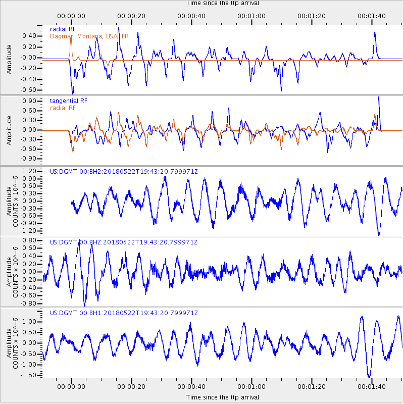
DGMT Dagmar, Montana, USA - Earthquake Result Viewer
*The percent match for this event was below the threshold and hence no stack was calculated.
| Earthquake location: |
Tonga Islands |
| Earthquake latitude/longitude: |
-17.9/-173.0 |
| Earthquake time(UTC): |
2018/05/22 (142) 19:30:53 GMT |
| Earthquake Depth: |
10 km |
| Earthquake Magnitude: |
5.4 mb |
| Earthquake Catalog/Contributor: |
NEIC PDE/us |
|
| Network: |
US United States National Seismic Network |
| Station: |
DGMT Dagmar, Montana, USA |
| Lat/Lon: |
48.47 N/104.20 W |
| Elevation: |
0.0 m |
|
| Distance: |
89.9 deg |
| Az: |
38.359 deg |
| Baz: |
242.626 deg |
| Ray Param: |
$rayparam |
*The percent match for this event was below the threshold and hence was not used in the summary stack. |
|
| Radial Match: |
57.889675 % |
| Radial Bump: |
400 |
| Transverse Match: |
60.151 % |
| Transverse Bump: |
400 |
| SOD ConfigId: |
2665671 |
| Insert Time: |
2018-06-05 19:35:11.646 +0000 |
| GWidth: |
2.5 |
| Max Bumps: |
400 |
| Tol: |
0.001 |
|
Signal To Noise
| Channel | StoN | STA | LTA |
| US:DGMT:00:BHZ:20180522T19:43:20.799971Z | 2.9265485 | 4.8832203E-7 | 1.6685938E-7 |
| US:DGMT:00:BH1:20180522T19:43:20.799971Z | 0.52292675 | 2.2516721E-7 | 4.3059038E-7 |
| US:DGMT:00:BH2:20180522T19:43:20.799971Z | 1.9727429 | 5.457541E-7 | 2.7664734E-7 |
| Arrivals |
| Ps | |
| PpPs | |
| PsPs/PpSs | |


