You are here: Home > Network List > UW - Pacific Northwest Regional Seismic Network Stations List
> Station UMAT Pilot Rock, OR, USA > Earthquake Result Viewer
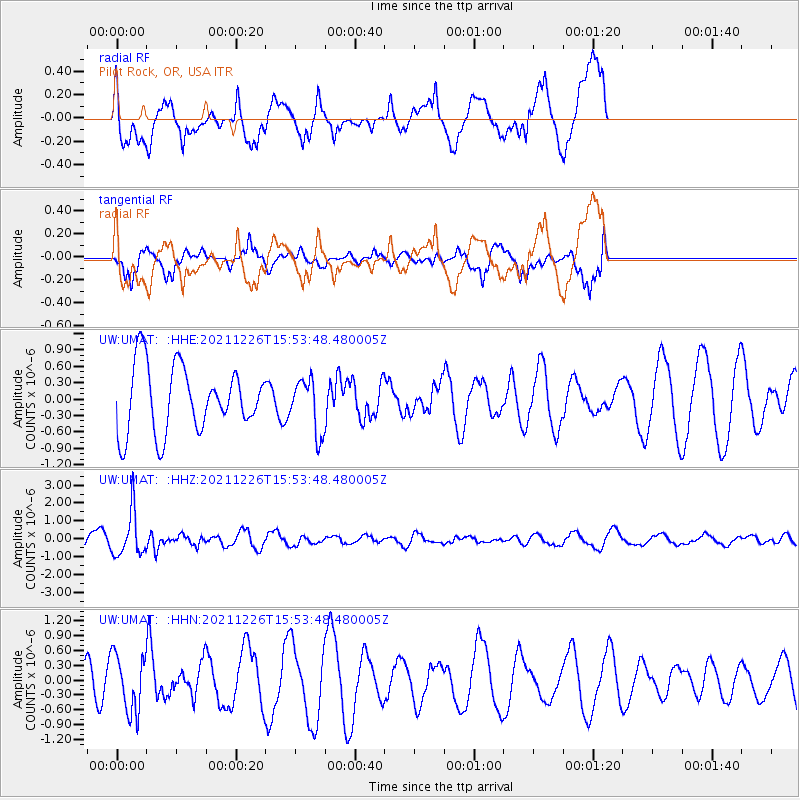
UMAT Pilot Rock, OR, USA - Earthquake Result Viewer
*The percent match for this event was below the threshold and hence no stack was calculated.
| Earthquake location: |
Fiji Islands Region |
| Earthquake latitude/longitude: |
-18.1/-179.4 |
| Earthquake time(UTC): |
2021/12/26 (360) 15:42:56 GMT |
| Earthquake Depth: |
627 km |
| Earthquake Magnitude: |
6.1 mww |
| Earthquake Catalog/Contributor: |
NEIC PDE/us |
|
| Network: |
UW Pacific Northwest Regional Seismic Network |
| Station: |
UMAT Pilot Rock, OR, USA |
| Lat/Lon: |
45.29 N/118.96 W |
| Elevation: |
1318 m |
|
| Distance: |
83.5 deg |
| Az: |
38.152 deg |
| Baz: |
236.351 deg |
| Ray Param: |
$rayparam |
*The percent match for this event was below the threshold and hence was not used in the summary stack. |
|
| Radial Match: |
77.00858 % |
| Radial Bump: |
400 |
| Transverse Match: |
63.305565 % |
| Transverse Bump: |
395 |
| SOD ConfigId: |
26694651 |
| Insert Time: |
2022-01-09 16:04:45.657 +0000 |
| GWidth: |
2.5 |
| Max Bumps: |
400 |
| Tol: |
0.001 |
|
Signal To Noise
| Channel | StoN | STA | LTA |
| UW:UMAT: :HHZ:20211226T15:53:48.480005Z | 2.9512758 | 1.2543339E-6 | 4.2501415E-7 |
| UW:UMAT: :HHN:20211226T15:53:48.480005Z | 1.151247 | 5.793529E-7 | 5.0323945E-7 |
| UW:UMAT: :HHE:20211226T15:53:48.480005Z | 0.80245346 | 4.8371334E-7 | 6.02793E-7 |
| Arrivals |
| Ps | |
| PpPs | |
| PsPs/PpSs | |


