You are here: Home > Network List > CI - Caltech Regional Seismic Network Stations List
> Station DAN Danby, California, USA > Earthquake Result Viewer
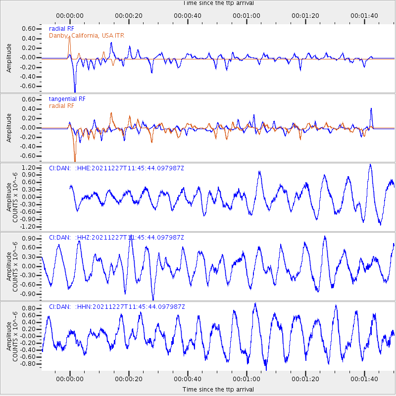
DAN Danby, California, USA - Earthquake Result Viewer
*The percent match for this event was below the threshold and hence no stack was calculated.
| Earthquake location: |
Tonga Islands |
| Earthquake latitude/longitude: |
-21.4/-173.9 |
| Earthquake time(UTC): |
2021/12/27 (361) 11:34:12 GMT |
| Earthquake Depth: |
10 km |
| Earthquake Magnitude: |
5.5 Mww |
| Earthquake Catalog/Contributor: |
NEIC PDE/us |
|
| Network: |
CI Caltech Regional Seismic Network |
| Station: |
DAN Danby, California, USA |
| Lat/Lon: |
34.64 N/115.38 W |
| Elevation: |
398 m |
|
| Distance: |
78.8 deg |
| Az: |
45.831 deg |
| Baz: |
234.134 deg |
| Ray Param: |
$rayparam |
*The percent match for this event was below the threshold and hence was not used in the summary stack. |
|
| Radial Match: |
44.239002 % |
| Radial Bump: |
400 |
| Transverse Match: |
52.04951 % |
| Transverse Bump: |
374 |
| SOD ConfigId: |
26694651 |
| Insert Time: |
2022-01-10 11:41:42.709 +0000 |
| GWidth: |
2.5 |
| Max Bumps: |
400 |
| Tol: |
0.001 |
|
Signal To Noise
| Channel | StoN | STA | LTA |
| CI:DAN: :HHZ:20211227T11:45:44.097987Z | 2.6039734 | 5.310923E-7 | 2.039546E-7 |
| CI:DAN: :HHN:20211227T11:45:44.097987Z | 0.8437555 | 2.3388542E-7 | 2.7719574E-7 |
| CI:DAN: :HHE:20211227T11:45:44.097987Z | 1.2166677 | 2.5358077E-7 | 2.0842238E-7 |
| Arrivals |
| Ps | |
| PpPs | |
| PsPs/PpSs | |


