You are here: Home > Network List > O2 - Oklahoma Consolidated Temporary Seismic Networks Stations List
> Station PW09 Ralston, Oklahoma > Earthquake Result Viewer
PW09 Ralston, Oklahoma - Earthquake Result Viewer
| Earthquake location: |
Tonga Islands |
| Earthquake latitude/longitude: |
-21.4/-173.9 |
| Earthquake time(UTC): |
2021/12/27 (361) 11:34:12 GMT |
| Earthquake Depth: |
10 km |
| Earthquake Magnitude: |
5.5 Mww |
| Earthquake Catalog/Contributor: |
NEIC PDE/us |
|
| Network: |
O2 Oklahoma Consolidated Temporary Seismic Networks |
| Station: |
PW09 Ralston, Oklahoma |
| Lat/Lon: |
36.45 N/96.82 W |
| Elevation: |
291 m |
|
| Distance: |
92.7 deg |
| Az: |
51.899 deg |
| Baz: |
245.396 deg |
| Ray Param: |
0.041406047 |
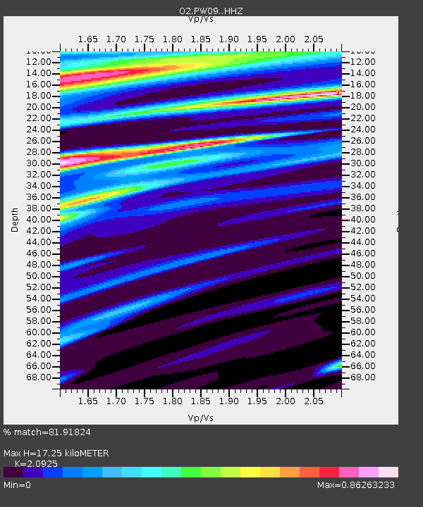
| Estimated Moho Depth: |
17.25 km |
| Estimated Crust Vp/Vs: |
2.09 |
| Assumed Crust Vp: |
6.483 km/s |
| Estimated Crust Vs: |
3.098 km/s |
| Estimated Crust Poisson's Ratio: |
0.35 |
|
| Radial Match: |
81.91824 % |
| Radial Bump: |
331 |
| Transverse Match: |
68.33546 % |
| Transverse Bump: |
400 |
| SOD ConfigId: |
26694651 |
| Insert Time: |
2022-01-10 11:47:34.977 +0000 |
| GWidth: |
2.5 |
| Max Bumps: |
400 |
| Tol: |
0.001 |
|

Signal To Noise
| Channel | StoN | STA | LTA |
| O2:PW09: :HHZ:20211227T11:46:53.464991Z | 1.4434987 | 7.998427E-7 | 5.5410004E-7 |
| O2:PW09: :HHN:20211227T11:46:53.464991Z | 1.9616873 | 8.8234475E-7 | 4.4978867E-7 |
| O2:PW09: :HHE:20211227T11:46:53.464991Z | 1.5034099 | 6.7606163E-7 | 4.496855E-7 |
| Arrivals |
| Ps | 3.0 SECOND |
| PpPs | 8.1 SECOND |
| PsPs/PpSs | 11 SECOND |


