You are here: Home > Network List > AE - Arizona Broadband Seismic Network Stations List
> Station BARN Flagstaff > Earthquake Result Viewer
BARN Flagstaff - Earthquake Result Viewer
| Earthquake location: |
Near Islands, Aleutian Islands |
| Earthquake latitude/longitude: |
54.7/170.6 |
| Earthquake time(UTC): |
2021/12/29 (363) 03:57:35 GMT |
| Earthquake Depth: |
26 km |
| Earthquake Magnitude: |
5.6 Mi |
| Earthquake Catalog/Contributor: |
NEIC PDE/at |
|
| Network: |
AE Arizona Broadband Seismic Network |
| Station: |
BARN Flagstaff |
| Lat/Lon: |
35.28 N/111.74 W |
| Elevation: |
2254 m |
|
| Distance: |
55.3 deg |
| Az: |
76.549 deg |
| Baz: |
316.334 deg |
| Ray Param: |
0.06487206 |
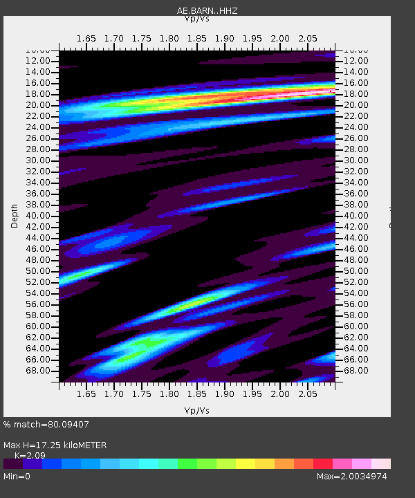
| Estimated Moho Depth: |
17.25 km |
| Estimated Crust Vp/Vs: |
2.09 |
| Assumed Crust Vp: |
6.207 km/s |
| Estimated Crust Vs: |
2.97 km/s |
| Estimated Crust Poisson's Ratio: |
0.35 |
|
| Radial Match: |
80.09407 % |
| Radial Bump: |
400 |
| Transverse Match: |
63.225838 % |
| Transverse Bump: |
400 |
| SOD ConfigId: |
26694651 |
| Insert Time: |
2022-01-12 03:59:27.180 +0000 |
| GWidth: |
2.5 |
| Max Bumps: |
400 |
| Tol: |
0.001 |
|

Signal To Noise
| Channel | StoN | STA | LTA |
| AE:BARN: :HHZ:20211229T04:06:35.01001Z | 5.4991918 | 5.775501E-7 | 1.0502454E-7 |
| AE:BARN: :HHN:20211229T04:06:35.01001Z | 2.3240137 | 2.7894828E-7 | 1.2002867E-7 |
| AE:BARN: :HHE:20211229T04:06:35.01001Z | 1.2605054 | 1.7501065E-7 | 1.3884166E-7 |
| Arrivals |
| Ps | 3.2 SECOND |
| PpPs | 8.2 SECOND |
| PsPs/PpSs | 11 SECOND |


