You are here: Home > Network List > CI - Caltech Regional Seismic Network Stations List
> Station GLA Glamis, Glamis, CA, USA > Earthquake Result Viewer
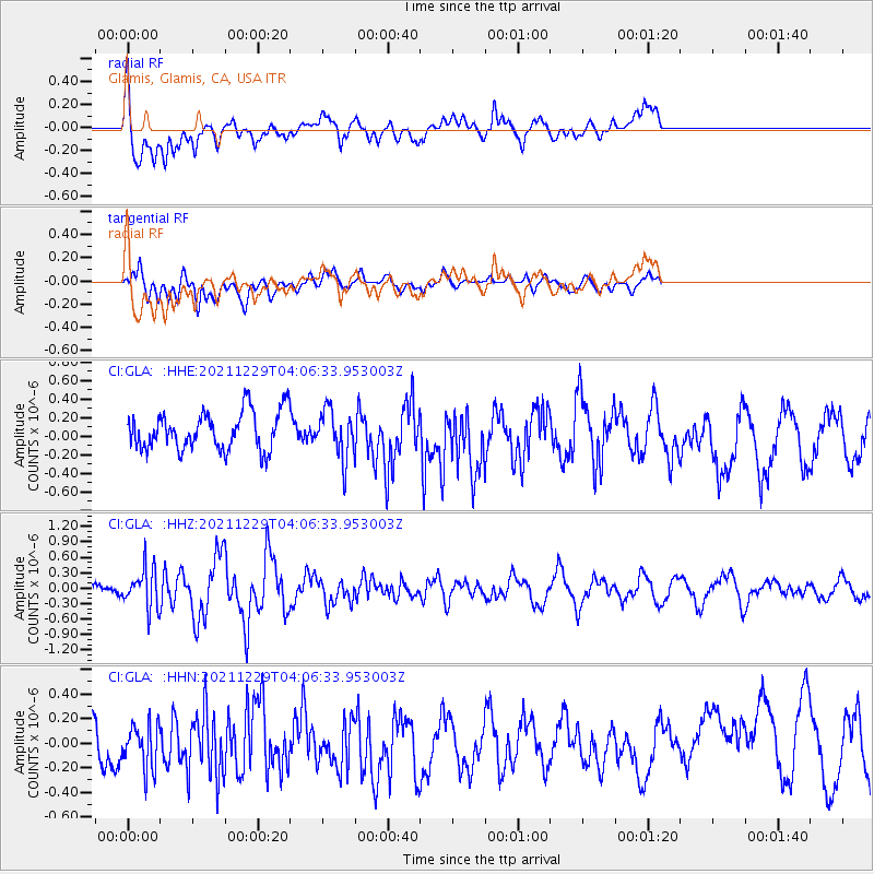
GLA Glamis, Glamis, CA, USA - Earthquake Result Viewer
*The percent match for this event was below the threshold and hence no stack was calculated.
| Earthquake location: |
Near Islands, Aleutian Islands |
| Earthquake latitude/longitude: |
54.7/170.6 |
| Earthquake time(UTC): |
2021/12/29 (363) 03:57:35 GMT |
| Earthquake Depth: |
26 km |
| Earthquake Magnitude: |
5.6 Mi |
| Earthquake Catalog/Contributor: |
NEIC PDE/at |
|
| Network: |
CI Caltech Regional Seismic Network |
| Station: |
GLA Glamis, Glamis, CA, USA |
| Lat/Lon: |
33.05 N/114.83 W |
| Elevation: |
610 m |
|
| Distance: |
55.1 deg |
| Az: |
80.675 deg |
| Baz: |
316.962 deg |
| Ray Param: |
$rayparam |
*The percent match for this event was below the threshold and hence was not used in the summary stack. |
|
| Radial Match: |
59.207245 % |
| Radial Bump: |
400 |
| Transverse Match: |
58.8267 % |
| Transverse Bump: |
400 |
| SOD ConfigId: |
26694651 |
| Insert Time: |
2022-01-12 04:03:04.509 +0000 |
| GWidth: |
2.5 |
| Max Bumps: |
400 |
| Tol: |
0.001 |
|
Signal To Noise
| Channel | StoN | STA | LTA |
| CI:GLA: :HHZ:20211229T04:06:33.953003Z | 1.1938865 | 3.7083186E-7 | 3.1060895E-7 |
| CI:GLA: :HHN:20211229T04:06:33.953003Z | 0.63022244 | 2.505285E-7 | 3.9752396E-7 |
| CI:GLA: :HHE:20211229T04:06:33.953003Z | 1.2459921 | 2.5588852E-7 | 2.0536932E-7 |
| Arrivals |
| Ps | |
| PpPs | |
| PsPs/PpSs | |


