You are here: Home > Network List > GS - US Geological Survey Networks Stations List
> Station DEC06 Boomer > Earthquake Result Viewer
DEC06 Boomer - Earthquake Result Viewer
*The percent match for this event was below the threshold and hence no stack was calculated.
| Earthquake location: |
Near Islands, Aleutian Islands |
| Earthquake latitude/longitude: |
54.7/170.6 |
| Earthquake time(UTC): |
2021/12/29 (363) 03:57:35 GMT |
| Earthquake Depth: |
26 km |
| Earthquake Magnitude: |
5.6 Mi |
| Earthquake Catalog/Contributor: |
NEIC PDE/at |
|
| Network: |
GS US Geological Survey Networks |
| Station: |
DEC06 Boomer |
| Lat/Lon: |
39.90 N/88.95 W |
| Elevation: |
215 m |
|
| Distance: |
63.9 deg |
| Az: |
57.384 deg |
| Baz: |
320.509 deg |
| Ray Param: |
$rayparam |
*The percent match for this event was below the threshold and hence was not used in the summary stack. |
|
| Radial Match: |
71.82892 % |
| Radial Bump: |
400 |
| Transverse Match: |
68.53503 % |
| Transverse Bump: |
400 |
| SOD ConfigId: |
26694651 |
| Insert Time: |
2022-01-12 04:07:08.454 +0000 |
| GWidth: |
2.5 |
| Max Bumps: |
400 |
| Tol: |
0.001 |
|
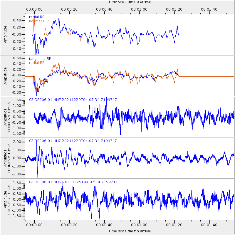
Signal To Noise
| Channel | StoN | STA | LTA |
| GS:DEC06:01:HHZ:20211229T04:07:34.719971Z | 2.3341126 | 7.835124E-7 | 3.3567892E-7 |
| GS:DEC06:01:HHN:20211229T04:07:34.719971Z | 0.93189895 | 4.6692955E-7 | 5.010517E-7 |
| GS:DEC06:01:HHE:20211229T04:07:34.719971Z | 1.3181242 | 4.397591E-7 | 3.3362494E-7 |
| Arrivals |
| Ps | |
| PpPs | |
| PsPs/PpSs | |


