You are here: Home > Network List > AK - Alaska Regional Network Stations List
> Station BPAW Bear Paw Mountain Broadband > Earthquake Result Viewer
BPAW Bear Paw Mountain Broadband - Earthquake Result Viewer
| Earthquake location: |
Banda Sea |
| Earthquake latitude/longitude: |
-7.6/127.6 |
| Earthquake time(UTC): |
2021/12/29 (363) 18:25:51 GMT |
| Earthquake Depth: |
167 km |
| Earthquake Magnitude: |
7.3 mww |
| Earthquake Catalog/Contributor: |
NEIC PDE/us |
|
| Network: |
AK Alaska Regional Network |
| Station: |
BPAW Bear Paw Mountain Broadband |
| Lat/Lon: |
64.10 N/150.98 W |
| Elevation: |
619 m |
|
| Distance: |
93.0 deg |
| Az: |
25.778 deg |
| Baz: |
259.014 deg |
| Ray Param: |
0.041247252 |
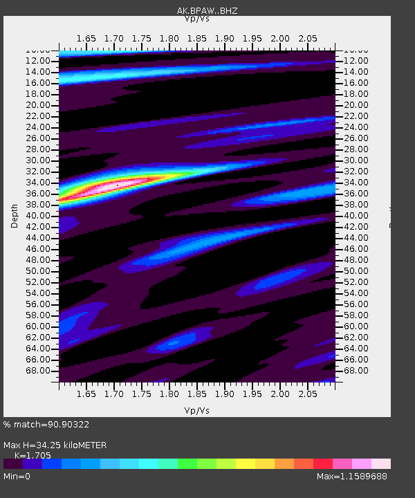
| Estimated Moho Depth: |
34.25 km |
| Estimated Crust Vp/Vs: |
1.71 |
| Assumed Crust Vp: |
6.566 km/s |
| Estimated Crust Vs: |
3.851 km/s |
| Estimated Crust Poisson's Ratio: |
0.24 |
|
| Radial Match: |
90.90322 % |
| Radial Bump: |
400 |
| Transverse Match: |
78.891655 % |
| Transverse Bump: |
400 |
| SOD ConfigId: |
26694651 |
| Insert Time: |
2022-01-12 18:27:01.750 +0000 |
| GWidth: |
2.5 |
| Max Bumps: |
400 |
| Tol: |
0.001 |
|

Signal To Noise
| Channel | StoN | STA | LTA |
| AK:BPAW: :BHZ:20211229T18:38:15.147996Z | 16.39617 | 3.9087217E-6 | 2.3839236E-7 |
| AK:BPAW: :BHN:20211229T18:38:15.147996Z | 1.3852519 | 5.1177136E-7 | 3.6944286E-7 |
| AK:BPAW: :BHE:20211229T18:38:15.147996Z | 3.5063272 | 1.0195829E-6 | 2.9078373E-7 |
| Arrivals |
| Ps | 3.8 SECOND |
| PpPs | 14 SECOND |
| PsPs/PpSs | 18 SECOND |


