You are here: Home > Network List > AK - Alaska Regional Network Stations List
> Station C23K Itkillik River, AK, USA > Earthquake Result Viewer
C23K Itkillik River, AK, USA - Earthquake Result Viewer
| Earthquake location: |
Banda Sea |
| Earthquake latitude/longitude: |
-7.6/127.6 |
| Earthquake time(UTC): |
2021/12/29 (363) 18:25:51 GMT |
| Earthquake Depth: |
167 km |
| Earthquake Magnitude: |
7.3 mww |
| Earthquake Catalog/Contributor: |
NEIC PDE/us |
|
| Network: |
AK Alaska Regional Network |
| Station: |
C23K Itkillik River, AK, USA |
| Lat/Lon: |
69.84 N/150.61 W |
| Elevation: |
179 m |
|
| Distance: |
94.3 deg |
| Az: |
20.131 deg |
| Baz: |
259.716 deg |
| Ray Param: |
0.040971402 |
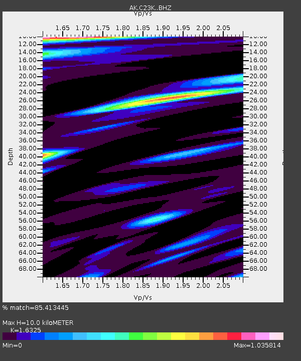
| Estimated Moho Depth: |
10.0 km |
| Estimated Crust Vp/Vs: |
1.63 |
| Assumed Crust Vp: |
6.221 km/s |
| Estimated Crust Vs: |
3.811 km/s |
| Estimated Crust Poisson's Ratio: |
0.20 |
|
| Radial Match: |
85.413445 % |
| Radial Bump: |
391 |
| Transverse Match: |
81.18174 % |
| Transverse Bump: |
400 |
| SOD ConfigId: |
26694651 |
| Insert Time: |
2022-01-12 18:27:11.564 +0000 |
| GWidth: |
2.5 |
| Max Bumps: |
400 |
| Tol: |
0.001 |
|

Signal To Noise
| Channel | StoN | STA | LTA |
| AK:C23K: :BHZ:20211229T18:38:20.66002Z | 9.216215 | 3.2918563E-6 | 3.5718094E-7 |
| AK:C23K: :BHN:20211229T18:38:20.66002Z | 2.4714572 | 5.1572107E-7 | 2.0867083E-7 |
| AK:C23K: :BHE:20211229T18:38:20.66002Z | 4.6323338 | 1.2853284E-6 | 2.7746887E-7 |
| Arrivals |
| Ps | 1.0 SECOND |
| PpPs | 4.1 SECOND |
| PsPs/PpSs | 5.2 SECOND |


