You are here: Home > Network List > AK - Alaska Regional Network Stations List
> Station K27K Chicken, AK, USA > Earthquake Result Viewer
K27K Chicken, AK, USA - Earthquake Result Viewer
| Earthquake location: |
Banda Sea |
| Earthquake latitude/longitude: |
-7.6/127.6 |
| Earthquake time(UTC): |
2021/12/29 (363) 18:25:51 GMT |
| Earthquake Depth: |
167 km |
| Earthquake Magnitude: |
7.3 mww |
| Earthquake Catalog/Contributor: |
NEIC PDE/us |
|
| Network: |
AK Alaska Regional Network |
| Station: |
K27K Chicken, AK, USA |
| Lat/Lon: |
64.03 N/142.08 W |
| Elevation: |
732 m |
|
| Distance: |
96.9 deg |
| Az: |
26.328 deg |
| Baz: |
266.971 deg |
| Ray Param: |
0.040229738 |
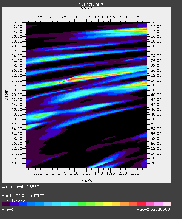
| Estimated Moho Depth: |
34.0 km |
| Estimated Crust Vp/Vs: |
1.76 |
| Assumed Crust Vp: |
6.566 km/s |
| Estimated Crust Vs: |
3.736 km/s |
| Estimated Crust Poisson's Ratio: |
0.26 |
|
| Radial Match: |
94.13887 % |
| Radial Bump: |
361 |
| Transverse Match: |
85.49476 % |
| Transverse Bump: |
400 |
| SOD ConfigId: |
26694651 |
| Insert Time: |
2022-01-12 18:28:49.949 +0000 |
| GWidth: |
2.5 |
| Max Bumps: |
400 |
| Tol: |
0.001 |
|

Signal To Noise
| Channel | StoN | STA | LTA |
| AK:K27K: :BHZ:20211229T18:38:32.679979Z | 16.14936 | 3.2659839E-6 | 2.0223612E-7 |
| AK:K27K: :BHN:20211229T18:38:32.679979Z | 2.0526028 | 3.0285184E-7 | 1.4754528E-7 |
| AK:K27K: :BHE:20211229T18:38:32.679979Z | 11.154503 | 1.1536067E-6 | 1.03420724E-7 |
| Arrivals |
| Ps | 4.0 SECOND |
| PpPs | 14 SECOND |
| PsPs/PpSs | 18 SECOND |


