You are here: Home > Network List > AK - Alaska Regional Network Stations List
> Station SAW Sawmill > Earthquake Result Viewer
SAW Sawmill - Earthquake Result Viewer
| Earthquake location: |
Banda Sea |
| Earthquake latitude/longitude: |
-7.6/127.6 |
| Earthquake time(UTC): |
2021/12/29 (363) 18:25:51 GMT |
| Earthquake Depth: |
167 km |
| Earthquake Magnitude: |
7.3 mww |
| Earthquake Catalog/Contributor: |
NEIC PDE/us |
|
| Network: |
AK Alaska Regional Network |
| Station: |
SAW Sawmill |
| Lat/Lon: |
61.81 N/148.33 W |
| Elevation: |
782 m |
|
| Distance: |
93.8 deg |
| Az: |
28.258 deg |
| Baz: |
261.228 deg |
| Ray Param: |
0.04106882 |
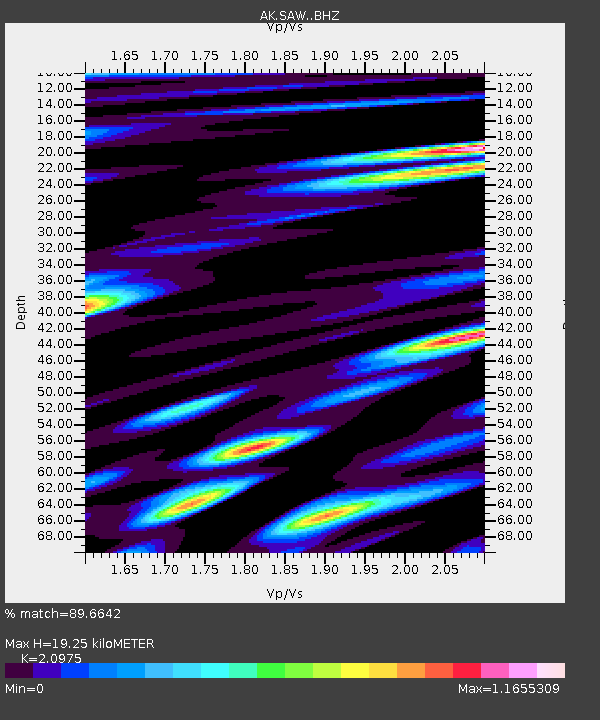
| Estimated Moho Depth: |
19.25 km |
| Estimated Crust Vp/Vs: |
2.10 |
| Assumed Crust Vp: |
6.566 km/s |
| Estimated Crust Vs: |
3.13 km/s |
| Estimated Crust Poisson's Ratio: |
0.35 |
|
| Radial Match: |
89.6642 % |
| Radial Bump: |
400 |
| Transverse Match: |
80.75679 % |
| Transverse Bump: |
400 |
| SOD ConfigId: |
26694651 |
| Insert Time: |
2022-01-12 18:30:26.919 +0000 |
| GWidth: |
2.5 |
| Max Bumps: |
400 |
| Tol: |
0.001 |
|

Signal To Noise
| Channel | StoN | STA | LTA |
| AK:SAW: :BHZ:20211229T18:38:18.80803Z | 17.71858 | 4.0873283E-6 | 2.3068037E-7 |
| AK:SAW: :BHN:20211229T18:38:18.80803Z | 2.1793394 | 4.9192914E-7 | 2.2572397E-7 |
| AK:SAW: :BHE:20211229T18:38:18.80803Z | 4.7487187 | 1.3597577E-6 | 2.8634201E-7 |
| Arrivals |
| Ps | 3.3 SECOND |
| PpPs | 8.9 SECOND |
| PsPs/PpSs | 12 SECOND |


