You are here: Home > Network List > AU - Australian Seismological Centre Stations List
> Station ARMA Armidale, New South Wales > Earthquake Result Viewer
ARMA Armidale, New South Wales - Earthquake Result Viewer
| Earthquake location: |
Banda Sea |
| Earthquake latitude/longitude: |
-7.6/127.6 |
| Earthquake time(UTC): |
2021/12/29 (363) 18:25:51 GMT |
| Earthquake Depth: |
167 km |
| Earthquake Magnitude: |
7.3 mww |
| Earthquake Catalog/Contributor: |
NEIC PDE/us |
|
| Network: |
AU Australian Seismological Centre |
| Station: |
ARMA Armidale, New South Wales |
| Lat/Lon: |
30.42 S/151.63 E |
| Elevation: |
1112 m |
|
| Distance: |
32.0 deg |
| Az: |
138.356 deg |
| Baz: |
310.307 deg |
| Ray Param: |
0.078351274 |
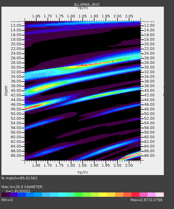
| Estimated Moho Depth: |
28.0 km |
| Estimated Crust Vp/Vs: |
1.91 |
| Assumed Crust Vp: |
6.577 km/s |
| Estimated Crust Vs: |
3.443 km/s |
| Estimated Crust Poisson's Ratio: |
0.31 |
|
| Radial Match: |
95.91592 % |
| Radial Bump: |
345 |
| Transverse Match: |
80.5793 % |
| Transverse Bump: |
400 |
| SOD ConfigId: |
26694651 |
| Insert Time: |
2022-01-12 18:31:06.203 +0000 |
| GWidth: |
2.5 |
| Max Bumps: |
400 |
| Tol: |
0.001 |
|

Signal To Noise
| Channel | StoN | STA | LTA |
| AU:ARMA: :BHZ:20211229T18:31:31.96901Z | 24.406078 | 6.1523924E-6 | 2.5208442E-7 |
| AU:ARMA: :BHN:20211229T18:31:31.96901Z | 16.795912 | 2.8858135E-6 | 1.7181642E-7 |
| AU:ARMA: :BHE:20211229T18:31:31.96901Z | 17.944685 | 3.3735457E-6 | 1.8799693E-7 |
| Arrivals |
| Ps | 4.2 SECOND |
| PpPs | 11 SECOND |
| PsPs/PpSs | 16 SECOND |


