You are here: Home > Network List > AV - Alaska Volcano Observatory Stations List
> Station AKBB Akutan Broiad Bright, Akutan Volcano, Alaska > Earthquake Result Viewer
AKBB Akutan Broiad Bright, Akutan Volcano, Alaska - Earthquake Result Viewer
| Earthquake location: |
Banda Sea |
| Earthquake latitude/longitude: |
-7.6/127.6 |
| Earthquake time(UTC): |
2021/12/29 (363) 18:25:51 GMT |
| Earthquake Depth: |
167 km |
| Earthquake Magnitude: |
7.3 mww |
| Earthquake Catalog/Contributor: |
NEIC PDE/us |
|
| Network: |
AV Alaska Volcano Observatory |
| Station: |
AKBB Akutan Broiad Bright, Akutan Volcano, Alaska |
| Lat/Lon: |
54.10 N/165.93 W |
| Elevation: |
310 m |
|
| Distance: |
82.7 deg |
| Az: |
32.989 deg |
| Baz: |
246.41 deg |
| Ray Param: |
0.04630826 |
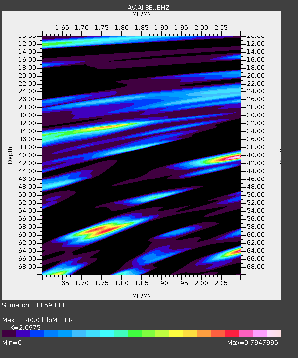
| Estimated Moho Depth: |
40.0 km |
| Estimated Crust Vp/Vs: |
2.10 |
| Assumed Crust Vp: |
5.989 km/s |
| Estimated Crust Vs: |
2.855 km/s |
| Estimated Crust Poisson's Ratio: |
0.35 |
|
| Radial Match: |
88.59333 % |
| Radial Bump: |
400 |
| Transverse Match: |
76.81085 % |
| Transverse Bump: |
400 |
| SOD ConfigId: |
26694651 |
| Insert Time: |
2022-01-12 18:31:22.458 +0000 |
| GWidth: |
2.5 |
| Max Bumps: |
400 |
| Tol: |
0.001 |
|

Signal To Noise
| Channel | StoN | STA | LTA |
| AV:AKBB: :BHZ:20211229T18:37:25.739976Z | 7.4209805 | 7.0018627E-6 | 9.435226E-7 |
| AV:AKBB: :BHN:20211229T18:37:25.739976Z | 1.5304306 | 1.4436071E-6 | 9.432686E-7 |
| AV:AKBB: :BHE:20211229T18:37:25.739976Z | 1.4522 | 2.0479356E-6 | 1.4102296E-6 |
| Arrivals |
| Ps | 7.5 SECOND |
| PpPs | 20 SECOND |
| PsPs/PpSs | 28 SECOND |


