You are here: Home > Network List > AV - Alaska Volcano Observatory Stations List
> Station AMKA Regional Station, Amchitka Island, Alaska > Earthquake Result Viewer
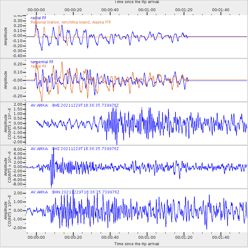
AMKA Regional Station, Amchitka Island, Alaska - Earthquake Result Viewer
*The percent match for this event was below the threshold and hence no stack was calculated.
| Earthquake location: |
Banda Sea |
| Earthquake latitude/longitude: |
-7.6/127.6 |
| Earthquake time(UTC): |
2021/12/29 (363) 18:25:51 GMT |
| Earthquake Depth: |
167 km |
| Earthquake Magnitude: |
7.3 mww |
| Earthquake Catalog/Contributor: |
NEIC PDE/us |
|
| Network: |
AV Alaska Volcano Observatory |
| Station: |
AMKA Regional Station, Amchitka Island, Alaska |
| Lat/Lon: |
51.38 N/179.30 E |
| Elevation: |
116 m |
|
| Distance: |
73.6 deg |
| Az: |
30.857 deg |
| Baz: |
234.222 deg |
| Ray Param: |
$rayparam |
*The percent match for this event was below the threshold and hence was not used in the summary stack. |
|
| Radial Match: |
76.66366 % |
| Radial Bump: |
400 |
| Transverse Match: |
65.75864 % |
| Transverse Bump: |
400 |
| SOD ConfigId: |
26694651 |
| Insert Time: |
2022-01-12 18:31:34.864 +0000 |
| GWidth: |
2.5 |
| Max Bumps: |
400 |
| Tol: |
0.001 |
|
Signal To Noise
| Channel | StoN | STA | LTA |
| AV:AMKA: :BHZ:20211229T18:36:35.739976Z | 3.3921838 | 8.3862284E-7 | 2.4722212E-7 |
| AV:AMKA: :BHN:20211229T18:36:35.739976Z | 1.1035482 | 2.1860345E-7 | 1.9809144E-7 |
| AV:AMKA: :BHE:20211229T18:36:35.739976Z | 1.7663306 | 4.2452803E-7 | 2.403446E-7 |
| Arrivals |
| Ps | |
| PpPs | |
| PsPs/PpSs | |


