You are here: Home > Network List > AV - Alaska Volcano Observatory Stations List
> Station CAHL Cahill, Katmai, Alaska > Earthquake Result Viewer
CAHL Cahill, Katmai, Alaska - Earthquake Result Viewer
| Earthquake location: |
Banda Sea |
| Earthquake latitude/longitude: |
-7.6/127.6 |
| Earthquake time(UTC): |
2021/12/29 (363) 18:25:51 GMT |
| Earthquake Depth: |
167 km |
| Earthquake Magnitude: |
7.3 mww |
| Earthquake Catalog/Contributor: |
NEIC PDE/us |
|
| Network: |
AV Alaska Volcano Observatory |
| Station: |
CAHL Cahill, Katmai, Alaska |
| Lat/Lon: |
58.05 N/155.30 W |
| Elevation: |
807 m |
|
| Distance: |
89.6 deg |
| Az: |
31.221 deg |
| Baz: |
255.107 deg |
| Ray Param: |
0.041720722 |
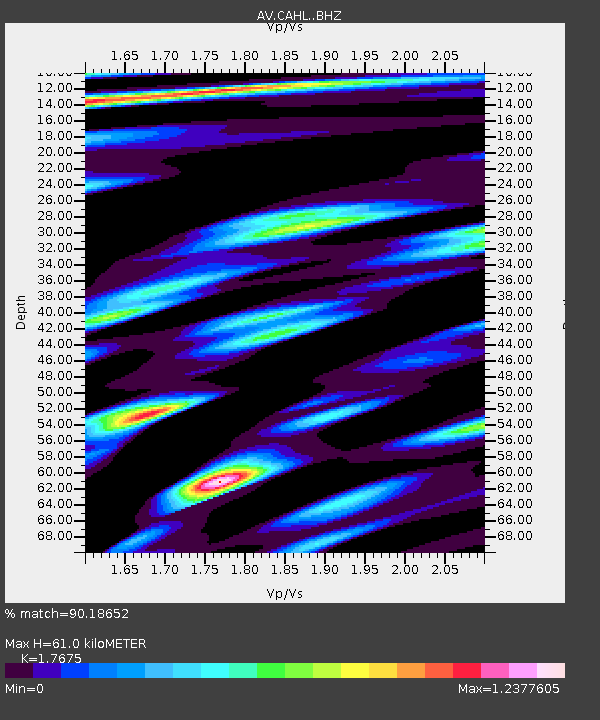
| Estimated Moho Depth: |
61.0 km |
| Estimated Crust Vp/Vs: |
1.77 |
| Assumed Crust Vp: |
6.438 km/s |
| Estimated Crust Vs: |
3.643 km/s |
| Estimated Crust Poisson's Ratio: |
0.26 |
|
| Radial Match: |
90.18652 % |
| Radial Bump: |
400 |
| Transverse Match: |
84.0415 % |
| Transverse Bump: |
400 |
| SOD ConfigId: |
26694651 |
| Insert Time: |
2022-01-12 18:31:50.132 +0000 |
| GWidth: |
2.5 |
| Max Bumps: |
400 |
| Tol: |
0.001 |
|

Signal To Noise
| Channel | StoN | STA | LTA |
| AV:CAHL: :BHZ:20211229T18:37:59.439988Z | 11.87125 | 5.961639E-6 | 5.0219137E-7 |
| AV:CAHL: :BHN:20211229T18:37:59.439988Z | 3.7410781 | 1.3536501E-6 | 3.6183422E-7 |
| AV:CAHL: :BHE:20211229T18:37:59.439988Z | 4.7635365 | 2.2352197E-6 | 4.6923537E-7 |
| Arrivals |
| Ps | 7.4 SECOND |
| PpPs | 26 SECOND |
| PsPs/PpSs | 33 SECOND |


