You are here: Home > Network List > AV - Alaska Volcano Observatory Stations List
> Station CESW Southwest, Cerberus Volcano, Alaska > Earthquake Result Viewer
CESW Southwest, Cerberus Volcano, Alaska - Earthquake Result Viewer
| Earthquake location: |
Banda Sea |
| Earthquake latitude/longitude: |
-7.6/127.6 |
| Earthquake time(UTC): |
2021/12/29 (363) 18:25:51 GMT |
| Earthquake Depth: |
167 km |
| Earthquake Magnitude: |
7.3 mww |
| Earthquake Catalog/Contributor: |
NEIC PDE/us |
|
| Network: |
AV Alaska Volcano Observatory |
| Station: |
CESW Southwest, Cerberus Volcano, Alaska |
| Lat/Lon: |
51.90 N/179.56 E |
| Elevation: |
238 m |
|
| Distance: |
74.0 deg |
| Az: |
30.514 deg |
| Baz: |
234.329 deg |
| Ray Param: |
0.05218606 |
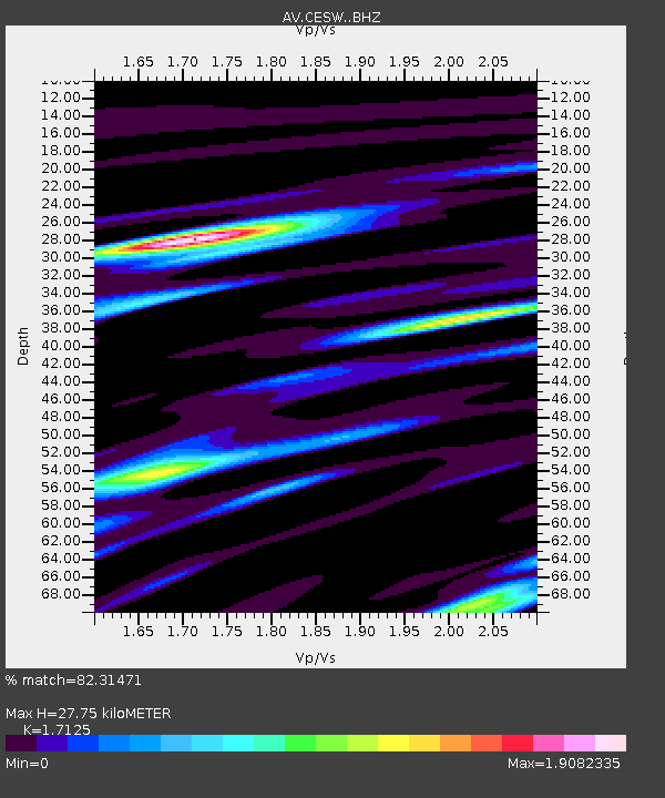
| Estimated Moho Depth: |
27.75 km |
| Estimated Crust Vp/Vs: |
1.71 |
| Assumed Crust Vp: |
6.183 km/s |
| Estimated Crust Vs: |
3.61 km/s |
| Estimated Crust Poisson's Ratio: |
0.24 |
|
| Radial Match: |
82.31471 % |
| Radial Bump: |
400 |
| Transverse Match: |
75.87011 % |
| Transverse Bump: |
400 |
| SOD ConfigId: |
26694651 |
| Insert Time: |
2022-01-12 18:31:56.873 +0000 |
| GWidth: |
2.5 |
| Max Bumps: |
400 |
| Tol: |
0.001 |
|

Signal To Noise
| Channel | StoN | STA | LTA |
| AV:CESW: :BHZ:20211229T18:36:38.259996Z | 5.354711 | 4.8892857E-6 | 9.130811E-7 |
| AV:CESW: :BHN:20211229T18:36:38.259996Z | 0.84908575 | 1.5099007E-6 | 1.7782666E-6 |
| AV:CESW: :BHE:20211229T18:36:38.259996Z | 1.4084911 | 1.9986637E-6 | 1.4190106E-6 |
| Arrivals |
| Ps | 3.3 SECOND |
| PpPs | 12 SECOND |
| PsPs/PpSs | 15 SECOND |


