You are here: Home > Network List > AV - Alaska Volcano Observatory Stations List
> Station GSIG Igitkin Island, Great Sitkin Volcano, Alaska > Earthquake Result Viewer
GSIG Igitkin Island, Great Sitkin Volcano, Alaska - Earthquake Result Viewer
| Earthquake location: |
Banda Sea |
| Earthquake latitude/longitude: |
-7.6/127.6 |
| Earthquake time(UTC): |
2021/12/29 (363) 18:25:51 GMT |
| Earthquake Depth: |
167 km |
| Earthquake Magnitude: |
7.3 mww |
| Earthquake Catalog/Contributor: |
NEIC PDE/us |
|
| Network: |
AV Alaska Volcano Observatory |
| Station: |
GSIG Igitkin Island, Great Sitkin Volcano, Alaska |
| Lat/Lon: |
51.99 N/175.93 W |
| Elevation: |
407 m |
|
| Distance: |
76.4 deg |
| Az: |
32.043 deg |
| Baz: |
238.264 deg |
| Ray Param: |
0.05060828 |
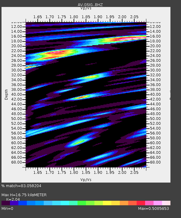
| Estimated Moho Depth: |
16.75 km |
| Estimated Crust Vp/Vs: |
2.04 |
| Assumed Crust Vp: |
3.943 km/s |
| Estimated Crust Vs: |
1.933 km/s |
| Estimated Crust Poisson's Ratio: |
0.34 |
|
| Radial Match: |
83.059204 % |
| Radial Bump: |
400 |
| Transverse Match: |
79.51414 % |
| Transverse Bump: |
400 |
| SOD ConfigId: |
26694651 |
| Insert Time: |
2022-01-12 18:32:19.057 +0000 |
| GWidth: |
2.5 |
| Max Bumps: |
400 |
| Tol: |
0.001 |
|

Signal To Noise
| Channel | StoN | STA | LTA |
| AV:GSIG: :BHZ:20211229T18:36:51.780015Z | 8.960713 | 6.497299E-6 | 7.2508726E-7 |
| AV:GSIG: :BHN:20211229T18:36:51.780015Z | 0.84732246 | 1.0461066E-6 | 1.2346028E-6 |
| AV:GSIG: :BHE:20211229T18:36:51.780015Z | 2.3577237 | 2.0465154E-6 | 8.680048E-7 |
| Arrivals |
| Ps | 4.5 SECOND |
| PpPs | 13 SECOND |
| PsPs/PpSs | 17 SECOND |


