You are here: Home > Network List > AV - Alaska Volcano Observatory Stations List
> Station GSMY Middle Yoke Creek, Great Sitkin Volcano, Alaska > Earthquake Result Viewer
GSMY Middle Yoke Creek, Great Sitkin Volcano, Alaska - Earthquake Result Viewer
| Earthquake location: |
Banda Sea |
| Earthquake latitude/longitude: |
-7.6/127.6 |
| Earthquake time(UTC): |
2021/12/29 (363) 18:25:51 GMT |
| Earthquake Depth: |
167 km |
| Earthquake Magnitude: |
7.3 mww |
| Earthquake Catalog/Contributor: |
NEIC PDE/us |
|
| Network: |
AV Alaska Volcano Observatory |
| Station: |
GSMY Middle Yoke Creek, Great Sitkin Volcano, Alaska |
| Lat/Lon: |
52.04 N/176.06 W |
| Elevation: |
418 m |
|
| Distance: |
76.4 deg |
| Az: |
31.949 deg |
| Baz: |
238.138 deg |
| Ray Param: |
0.050632283 |
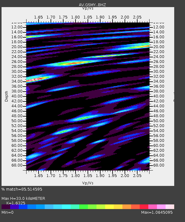
| Estimated Moho Depth: |
33.0 km |
| Estimated Crust Vp/Vs: |
1.63 |
| Assumed Crust Vp: |
3.912 km/s |
| Estimated Crust Vs: |
2.396 km/s |
| Estimated Crust Poisson's Ratio: |
0.20 |
|
| Radial Match: |
85.514595 % |
| Radial Bump: |
400 |
| Transverse Match: |
71.07781 % |
| Transverse Bump: |
400 |
| SOD ConfigId: |
26694651 |
| Insert Time: |
2022-01-12 18:32:19.539 +0000 |
| GWidth: |
2.5 |
| Max Bumps: |
400 |
| Tol: |
0.001 |
|

Signal To Noise
| Channel | StoN | STA | LTA |
| AV:GSMY: :BHZ:20211229T18:36:51.559983Z | 8.441249 | 6.6414154E-6 | 7.8678113E-7 |
| AV:GSMY: :BHN:20211229T18:36:51.559983Z | 3.0621884 | 2.4697051E-6 | 8.0651637E-7 |
| AV:GSMY: :BHE:20211229T18:36:51.559983Z | 3.5330515 | 2.9750613E-6 | 8.420656E-7 |
| Arrivals |
| Ps | 5.4 SECOND |
| PpPs | 22 SECOND |
| PsPs/PpSs | 27 SECOND |


