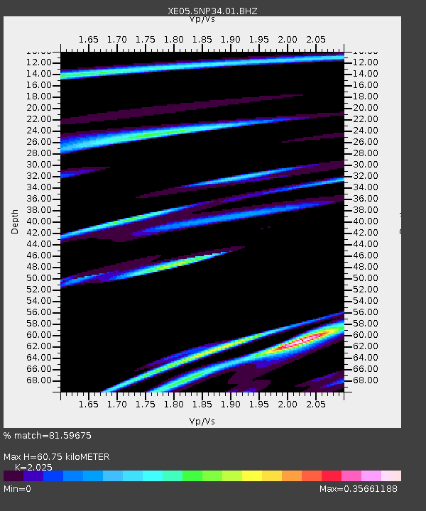
SNP34 SNP34 - Earthquake Result Viewer

Earthquake location: Loyalty Islands
Earthquake latitude/longitude: -20.6/169.0
Earthquake time(UTC): 2007/04/03 (093) 20:26:09 GMT
Earthquake Depth: 12 km
Earthquake Magnitude: 5.6 MB, 6.0 MS, 6.2 MW, 6.1 MW
Earthquake Catalog/Contributor: WHDF/NEIC
Network: XE Sierra Nevada EarthScope Project- EarthScope Flex Array
Station: SNP34 SNP34
Lat/Lon: 37.39 N/119.06 W
Elevation: 2401 m
Distance: 88.9 deg
Az: 49.235 deg
Baz: 242.958 deg
Ray Param: 0.042247657
Estimated Moho Depth: 60.75 km
Estimated Crust Vp/Vs: 2.03
Assumed Crust Vp: 6.291 km/s
Estimated Crust Vs: 3.107 km/s
Estimated Crust Poisson's Ratio: 0.34
Radial Match: 81.59675 %
Radial Bump: 400
Transverse Match: 53.78415 %
Transverse Bump: 400
SOD ConfigId: 268666
Insert Time: 2010-03-09 15:25:06.649 +0000
GWidth: 2.5
Max Bumps: 400
Tol: 0.001

Signal To Noise

ChannelStoNSTALTA
XE:SNP34:01:BHZ:20070403T20:38:32.090Z2.79716285.362089E-71.9169744E-7
XE:SNP34:01:BHN:20070403T20:38:32.090Z0.51641518.73462E-81.6913951E-7
XE:SNP34:01:BHE:20070403T20:38:32.090Z1.48357652.8393387E-71.9138471E-7
Arrivals
Ps10 SECOND
PpPs29 SECOND
PsPs/PpSs39 SECOND