You are here: Home > Network List > AV - Alaska Volcano Observatory Stations List
> Station KICM Cape Miga, Kanaga Volcano, Alaska > Earthquake Result Viewer
KICM Cape Miga, Kanaga Volcano, Alaska - Earthquake Result Viewer
| Earthquake location: |
Banda Sea |
| Earthquake latitude/longitude: |
-7.6/127.6 |
| Earthquake time(UTC): |
2021/12/29 (363) 18:25:51 GMT |
| Earthquake Depth: |
167 km |
| Earthquake Magnitude: |
7.3 mww |
| Earthquake Catalog/Contributor: |
NEIC PDE/us |
|
| Network: |
AV Alaska Volcano Observatory |
| Station: |
KICM Cape Miga, Kanaga Volcano, Alaska |
| Lat/Lon: |
51.92 N/177.20 W |
| Elevation: |
183 m |
|
| Distance: |
75.7 deg |
| Az: |
31.669 deg |
| Baz: |
237.176 deg |
| Ray Param: |
0.05107994 |
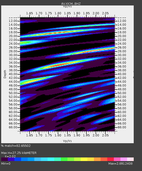
| Estimated Moho Depth: |
27.25 km |
| Estimated Crust Vp/Vs: |
2.02 |
| Assumed Crust Vp: |
5.88 km/s |
| Estimated Crust Vs: |
2.911 km/s |
| Estimated Crust Poisson's Ratio: |
0.34 |
|
| Radial Match: |
82.65502 % |
| Radial Bump: |
400 |
| Transverse Match: |
71.20704 % |
| Transverse Bump: |
400 |
| SOD ConfigId: |
26694651 |
| Insert Time: |
2022-01-12 18:32:45.664 +0000 |
| GWidth: |
2.5 |
| Max Bumps: |
400 |
| Tol: |
0.001 |
|

Signal To Noise
| Channel | StoN | STA | LTA |
| AV:KICM: :BHZ:20211229T18:36:47.819993Z | 6.7438717 | 7.5432263E-6 | 1.1185305E-6 |
| AV:KICM: :BHN:20211229T18:36:47.819993Z | 1.2242815 | 2.765885E-6 | 2.2591903E-6 |
| AV:KICM: :BHE:20211229T18:36:47.819993Z | 2.0282514 | 5.0888757E-6 | 2.5089964E-6 |
| Arrivals |
| Ps | 4.8 SECOND |
| PpPs | 14 SECOND |
| PsPs/PpSs | 19 SECOND |


