You are here: Home > Network List > AV - Alaska Volcano Observatory Stations List
> Station KIWB Westway Bight, Kanaga Volcano, Alaska > Earthquake Result Viewer
KIWB Westway Bight, Kanaga Volcano, Alaska - Earthquake Result Viewer
| Earthquake location: |
Banda Sea |
| Earthquake latitude/longitude: |
-7.6/127.6 |
| Earthquake time(UTC): |
2021/12/29 (363) 18:25:51 GMT |
| Earthquake Depth: |
167 km |
| Earthquake Magnitude: |
7.3 mww |
| Earthquake Catalog/Contributor: |
NEIC PDE/us |
|
| Network: |
AV Alaska Volcano Observatory |
| Station: |
KIWB Westway Bight, Kanaga Volcano, Alaska |
| Lat/Lon: |
51.85 N/177.15 W |
| Elevation: |
244 m |
|
| Distance: |
75.7 deg |
| Az: |
31.742 deg |
| Baz: |
237.228 deg |
| Ray Param: |
0.051088054 |
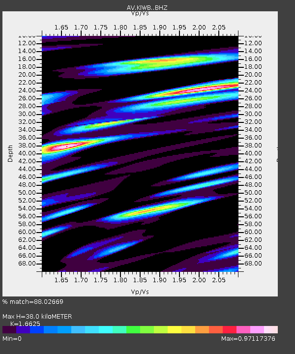
| Estimated Moho Depth: |
38.0 km |
| Estimated Crust Vp/Vs: |
1.66 |
| Assumed Crust Vp: |
5.88 km/s |
| Estimated Crust Vs: |
3.537 km/s |
| Estimated Crust Poisson's Ratio: |
0.22 |
|
| Radial Match: |
88.02669 % |
| Radial Bump: |
400 |
| Transverse Match: |
83.97981 % |
| Transverse Bump: |
400 |
| SOD ConfigId: |
26694651 |
| Insert Time: |
2022-01-12 18:32:56.130 +0000 |
| GWidth: |
2.5 |
| Max Bumps: |
400 |
| Tol: |
0.001 |
|
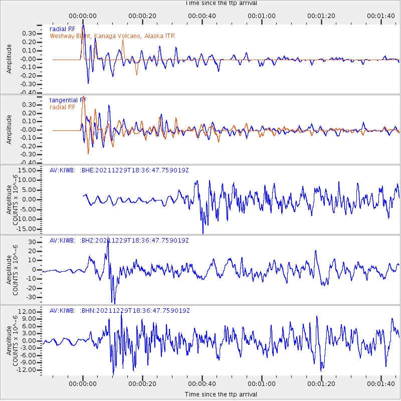
Signal To Noise
| Channel | StoN | STA | LTA |
| AV:KIWB: :BHZ:20211229T18:36:47.759019Z | 8.580818 | 7.208914E-6 | 8.4011975E-7 |
| AV:KIWB: :BHN:20211229T18:36:47.759019Z | 1.6785583 | 1.5225397E-6 | 9.070521E-7 |
| AV:KIWB: :BHE:20211229T18:36:47.759019Z | 1.8169341 | 2.2978493E-6 | 1.264685E-6 |
| Arrivals |
| Ps | 4.4 SECOND |
| PpPs | 17 SECOND |
| PsPs/PpSs | 21 SECOND |


