You are here: Home > Network List > AV - Alaska Volcano Observatory Stations List
> Station KOKL Mount Kliuchef, Korovin Volcano, Alaska > Earthquake Result Viewer
KOKL Mount Kliuchef, Korovin Volcano, Alaska - Earthquake Result Viewer
| Earthquake location: |
Banda Sea |
| Earthquake latitude/longitude: |
-7.6/127.6 |
| Earthquake time(UTC): |
2021/12/29 (363) 18:25:51 GMT |
| Earthquake Depth: |
167 km |
| Earthquake Magnitude: |
7.3 mww |
| Earthquake Catalog/Contributor: |
NEIC PDE/us |
|
| Network: |
AV Alaska Volcano Observatory |
| Station: |
KOKL Mount Kliuchef, Korovin Volcano, Alaska |
| Lat/Lon: |
52.32 N/174.20 W |
| Elevation: |
758 m |
|
| Distance: |
77.5 deg |
| Az: |
32.308 deg |
| Baz: |
239.682 deg |
| Ray Param: |
0.049889185 |
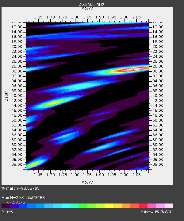
| Estimated Moho Depth: |
29.0 km |
| Estimated Crust Vp/Vs: |
2.04 |
| Assumed Crust Vp: |
5.88 km/s |
| Estimated Crust Vs: |
2.886 km/s |
| Estimated Crust Poisson's Ratio: |
0.34 |
|
| Radial Match: |
93.55765 % |
| Radial Bump: |
400 |
| Transverse Match: |
79.42114 % |
| Transverse Bump: |
400 |
| SOD ConfigId: |
26694651 |
| Insert Time: |
2022-01-12 18:32:59.344 +0000 |
| GWidth: |
2.5 |
| Max Bumps: |
400 |
| Tol: |
0.001 |
|

Signal To Noise
| Channel | StoN | STA | LTA |
| AV:KOKL: :BHZ:20211229T18:36:57.819017Z | 8.586161 | 7.734085E-6 | 9.007617E-7 |
| AV:KOKL: :BHN:20211229T18:36:57.819017Z | 1.3147826 | 2.381877E-6 | 1.8116127E-6 |
| AV:KOKL: :BHE:20211229T18:36:57.819017Z | 2.5752294 | 3.8456265E-6 | 1.4933141E-6 |
| Arrivals |
| Ps | 5.2 SECOND |
| PpPs | 15 SECOND |
| PsPs/PpSs | 20 SECOND |


