You are here: Home > Network List > AV - Alaska Volcano Observatory Stations List
> Station LSNW Northwest, Little Sitkin Volcano, Alaska > Earthquake Result Viewer
LSNW Northwest, Little Sitkin Volcano, Alaska - Earthquake Result Viewer
| Earthquake location: |
Banda Sea |
| Earthquake latitude/longitude: |
-7.6/127.6 |
| Earthquake time(UTC): |
2021/12/29 (363) 18:25:51 GMT |
| Earthquake Depth: |
167 km |
| Earthquake Magnitude: |
7.3 mww |
| Earthquake Catalog/Contributor: |
NEIC PDE/us |
|
| Network: |
AV Alaska Volcano Observatory |
| Station: |
LSNW Northwest, Little Sitkin Volcano, Alaska |
| Lat/Lon: |
51.97 N/178.51 E |
| Elevation: |
290 m |
|
| Distance: |
73.5 deg |
| Az: |
30.057 deg |
| Baz: |
233.38 deg |
| Ray Param: |
0.05251311 |
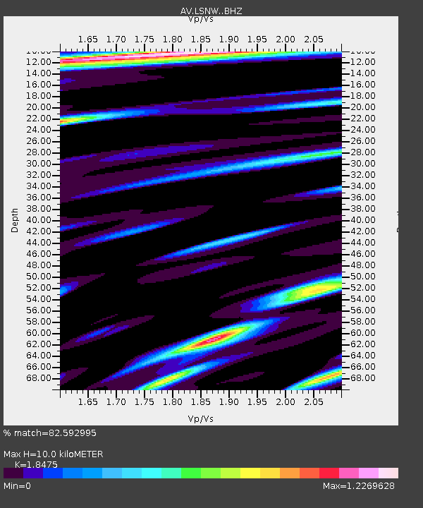
| Estimated Moho Depth: |
10.0 km |
| Estimated Crust Vp/Vs: |
1.85 |
| Assumed Crust Vp: |
6.183 km/s |
| Estimated Crust Vs: |
3.346 km/s |
| Estimated Crust Poisson's Ratio: |
0.29 |
|
| Radial Match: |
82.592995 % |
| Radial Bump: |
400 |
| Transverse Match: |
62.62272 % |
| Transverse Bump: |
400 |
| SOD ConfigId: |
26694651 |
| Insert Time: |
2022-01-12 18:33:09.558 +0000 |
| GWidth: |
2.5 |
| Max Bumps: |
400 |
| Tol: |
0.001 |
|

Signal To Noise
| Channel | StoN | STA | LTA |
| AV:LSNW: :BHZ:20211229T18:36:35.480027Z | 5.2350287 | 5.586218E-6 | 1.0670844E-6 |
| AV:LSNW: :BHN:20211229T18:36:35.480027Z | 1.7862128 | 3.4234415E-6 | 1.9165923E-6 |
| AV:LSNW: :BHE:20211229T18:36:35.480027Z | 2.3583844 | 3.739839E-6 | 1.5857631E-6 |
| Arrivals |
| Ps | 1.4 SECOND |
| PpPs | 4.5 SECOND |
| PsPs/PpSs | 5.9 SECOND |


