You are here: Home > Network List > AV - Alaska Volcano Observatory Stations List
> Station P19K Oil Pt, AK, USA > Earthquake Result Viewer
P19K Oil Pt, AK, USA - Earthquake Result Viewer
| Earthquake location: |
Banda Sea |
| Earthquake latitude/longitude: |
-7.6/127.6 |
| Earthquake time(UTC): |
2021/12/29 (363) 18:25:51 GMT |
| Earthquake Depth: |
167 km |
| Earthquake Magnitude: |
7.3 mww |
| Earthquake Catalog/Contributor: |
NEIC PDE/us |
|
| Network: |
AV Alaska Volcano Observatory |
| Station: |
P19K Oil Pt, AK, USA |
| Lat/Lon: |
59.65 N/153.23 W |
| Elevation: |
629 m |
|
| Distance: |
91.1 deg |
| Az: |
29.924 deg |
| Baz: |
256.885 deg |
| Ray Param: |
0.04159101 |
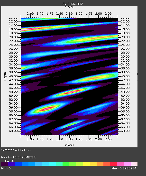
| Estimated Moho Depth: |
16.0 km |
| Estimated Crust Vp/Vs: |
1.60 |
| Assumed Crust Vp: |
5.989 km/s |
| Estimated Crust Vs: |
3.743 km/s |
| Estimated Crust Poisson's Ratio: |
0.18 |
|
| Radial Match: |
83.21522 % |
| Radial Bump: |
400 |
| Transverse Match: |
74.934105 % |
| Transverse Bump: |
400 |
| SOD ConfigId: |
26694651 |
| Insert Time: |
2022-01-12 18:33:38.101 +0000 |
| GWidth: |
2.5 |
| Max Bumps: |
400 |
| Tol: |
0.001 |
|

Signal To Noise
| Channel | StoN | STA | LTA |
| AV:P19K: :BHZ:20211229T18:38:06.074998Z | 7.1524763 | 5.0105573E-6 | 7.005346E-7 |
| AV:P19K: :BHN:20211229T18:38:06.074998Z | 1.5934069 | 8.7509625E-7 | 5.4919826E-7 |
| AV:P19K: :BHE:20211229T18:38:06.074998Z | 1.5641905 | 1.1875849E-6 | 7.592329E-7 |
| Arrivals |
| Ps | 1.6 SECOND |
| PpPs | 6.8 SECOND |
| PsPs/PpSs | 8.4 SECOND |


