You are here: Home > Network List > AV - Alaska Volcano Observatory Stations List
> Station PLK2 Mt. Peulik Volcano 2, Alaska > Earthquake Result Viewer
PLK2 Mt. Peulik Volcano 2, Alaska - Earthquake Result Viewer
| Earthquake location: |
Banda Sea |
| Earthquake latitude/longitude: |
-7.6/127.6 |
| Earthquake time(UTC): |
2021/12/29 (363) 18:25:51 GMT |
| Earthquake Depth: |
167 km |
| Earthquake Magnitude: |
7.3 mww |
| Earthquake Catalog/Contributor: |
NEIC PDE/us |
|
| Network: |
AV Alaska Volcano Observatory |
| Station: |
PLK2 Mt. Peulik Volcano 2, Alaska |
| Lat/Lon: |
57.76 N/156.33 W |
| Elevation: |
401 m |
|
| Distance: |
89.0 deg |
| Az: |
31.355 deg |
| Baz: |
254.244 deg |
| Ray Param: |
0.041782513 |
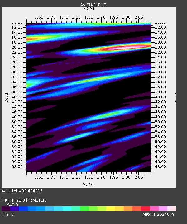
| Estimated Moho Depth: |
20.0 km |
| Estimated Crust Vp/Vs: |
2.00 |
| Assumed Crust Vp: |
6.1 km/s |
| Estimated Crust Vs: |
3.05 km/s |
| Estimated Crust Poisson's Ratio: |
0.33 |
|
| Radial Match: |
83.404015 % |
| Radial Bump: |
400 |
| Transverse Match: |
74.05699 % |
| Transverse Bump: |
400 |
| SOD ConfigId: |
26694651 |
| Insert Time: |
2022-01-12 18:33:41.628 +0000 |
| GWidth: |
2.5 |
| Max Bumps: |
400 |
| Tol: |
0.001 |
|

Signal To Noise
| Channel | StoN | STA | LTA |
| AV:PLK2: :BHZ:20211229T18:37:56.640Z | 16.440365 | 4.399069E-6 | 2.6757735E-7 |
| AV:PLK2: :BHN:20211229T18:37:56.640Z | 4.7740912 | 8.8812584E-7 | 1.8603033E-7 |
| AV:PLK2: :BHE:20211229T18:37:56.640Z | 5.7225757 | 1.2973751E-6 | 2.2671173E-7 |
| Arrivals |
| Ps | 3.3 SECOND |
| PpPs | 9.7 SECOND |
| PsPs/PpSs | 13 SECOND |


