You are here: Home > Network List > AV - Alaska Volcano Observatory Stations List
> Station S14K Fog Glacier, AK, USA > Earthquake Result Viewer
S14K Fog Glacier, AK, USA - Earthquake Result Viewer
| Earthquake location: |
Banda Sea |
| Earthquake latitude/longitude: |
-7.6/127.6 |
| Earthquake time(UTC): |
2021/12/29 (363) 18:25:51 GMT |
| Earthquake Depth: |
167 km |
| Earthquake Magnitude: |
7.3 mww |
| Earthquake Catalog/Contributor: |
NEIC PDE/us |
|
| Network: |
AV Alaska Volcano Observatory |
| Station: |
S14K Fog Glacier, AK, USA |
| Lat/Lon: |
56.28 N/159.55 W |
| Elevation: |
1059 m |
|
| Distance: |
86.9 deg |
| Az: |
32.254 deg |
| Baz: |
251.574 deg |
| Ray Param: |
0.04333125 |
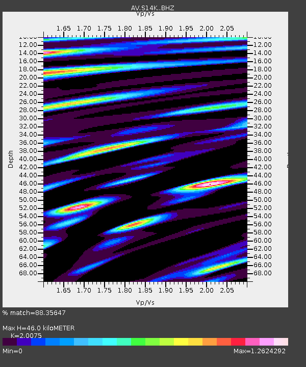
| Estimated Moho Depth: |
46.0 km |
| Estimated Crust Vp/Vs: |
2.01 |
| Assumed Crust Vp: |
6.134 km/s |
| Estimated Crust Vs: |
3.055 km/s |
| Estimated Crust Poisson's Ratio: |
0.33 |
|
| Radial Match: |
88.35647 % |
| Radial Bump: |
400 |
| Transverse Match: |
78.549515 % |
| Transverse Bump: |
400 |
| SOD ConfigId: |
26694651 |
| Insert Time: |
2022-01-12 18:34:09.436 +0000 |
| GWidth: |
2.5 |
| Max Bumps: |
400 |
| Tol: |
0.001 |
|

Signal To Noise
| Channel | StoN | STA | LTA |
| AV:S14K: :BHZ:20211229T18:37:46.624986Z | 9.617571 | 1.128432E-5 | 1.1733025E-6 |
| AV:S14K: :BHN:20211229T18:37:46.624986Z | 1.9632586 | 3.1834024E-6 | 1.6214891E-6 |
| AV:S14K: :BHE:20211229T18:37:46.624986Z | 3.0265949 | 4.829895E-6 | 1.5958182E-6 |
| Arrivals |
| Ps | 7.7 SECOND |
| PpPs | 22 SECOND |
| PsPs/PpSs | 30 SECOND |


