You are here: Home > Network List > BX - Botswana Seismological Network Stations List
> Station MREMI Moremi > Earthquake Result Viewer
MREMI Moremi - Earthquake Result Viewer
| Earthquake location: |
Banda Sea |
| Earthquake latitude/longitude: |
-7.6/127.6 |
| Earthquake time(UTC): |
2021/12/29 (363) 18:25:51 GMT |
| Earthquake Depth: |
167 km |
| Earthquake Magnitude: |
7.3 mww |
| Earthquake Catalog/Contributor: |
NEIC PDE/us |
|
| Network: |
BX Botswana Seismological Network |
| Station: |
MREMI Moremi |
| Lat/Lon: |
22.57 S/27.45 E |
| Elevation: |
911 m |
|
| Distance: |
96.4 deg |
| Az: |
246.287 deg |
| Baz: |
100.898 deg |
| Ray Param: |
0.04039195 |
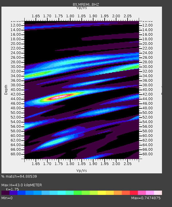
| Estimated Moho Depth: |
43.0 km |
| Estimated Crust Vp/Vs: |
1.75 |
| Assumed Crust Vp: |
6.459 km/s |
| Estimated Crust Vs: |
3.691 km/s |
| Estimated Crust Poisson's Ratio: |
0.26 |
|
| Radial Match: |
94.88539 % |
| Radial Bump: |
225 |
| Transverse Match: |
86.86686 % |
| Transverse Bump: |
340 |
| SOD ConfigId: |
26694651 |
| Insert Time: |
2022-01-12 18:34:58.611 +0000 |
| GWidth: |
2.5 |
| Max Bumps: |
400 |
| Tol: |
0.001 |
|

Signal To Noise
| Channel | StoN | STA | LTA |
| BX:MREMI: :BHZ:20211229T18:38:30.285997Z | 12.233729 | 3.2507735E-6 | 2.6572218E-7 |
| BX:MREMI: :BHN:20211229T18:38:30.285997Z | 0.8016579 | 2.8507657E-7 | 3.5560873E-7 |
| BX:MREMI: :BHE:20211229T18:38:30.285997Z | 3.0749185 | 8.486188E-7 | 2.759809E-7 |
| Arrivals |
| Ps | 5.1 SECOND |
| PpPs | 18 SECOND |
| PsPs/PpSs | 23 SECOND |


