You are here: Home > Network List > G - GEOSCOPE Stations List
> Station AIS New Amsterdam, Indian Ocean > Earthquake Result Viewer
AIS New Amsterdam, Indian Ocean - Earthquake Result Viewer

| Earthquake location: |
Banda Sea |
| Earthquake latitude/longitude: |
-7.6/127.6 |
| Earthquake time(UTC): |
2021/12/29 (363) 18:25:51 GMT |
| Earthquake Depth: |
167 km |
| Earthquake Magnitude: |
7.3 mww |
| Earthquake Catalog/Contributor: |
NEIC PDE/us |
|
| Network: |
G GEOSCOPE |
| Station: |
AIS New Amsterdam, Indian Ocean |
| Lat/Lon: |
37.80 S/77.57 E |
| Elevation: |
35 m |
|
| Distance: |
54.2 deg |
| Az: |
228.436 deg |
| Baz: |
69.444 deg |
| Ray Param: |
0.06503921 |
| Estimated Moho Depth: |
10.0 km |
| Estimated Crust Vp/Vs: |
1.60 |
| Assumed Crust Vp: |
4.802 km/s |
| Estimated Crust Vs: |
3.001 km/s |
| Estimated Crust Poisson's Ratio: |
0.18 |
|
| Radial Match: |
82.32796 % |
| Radial Bump: |
383 |
| Transverse Match: |
82.6766 % |
| Transverse Bump: |
400 |
| SOD ConfigId: |
26694651 |
| Insert Time: |
2022-01-12 18:35:10.150 +0000 |
| GWidth: |
2.5 |
| Max Bumps: |
400 |
| Tol: |
0.001 |
|
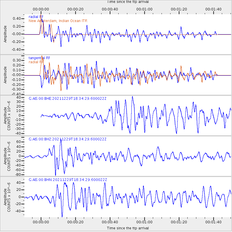
Signal To Noise
| Channel | StoN | STA | LTA |
| G:AIS:00:BHZ:20211229T18:34:29.600022Z | 4.105323 | 9.892756E-6 | 2.4097387E-6 |
| G:AIS:00:BHN:20211229T18:34:29.600022Z | 0.9901893 | 3.5931162E-6 | 3.6287165E-6 |
| G:AIS:00:BHE:20211229T18:34:29.600022Z | 1.287638 | 4.3304503E-6 | 3.3630963E-6 |
| Arrivals |
| Ps | 1.3 SECOND |
| PpPs | 5.2 SECOND |
| PsPs/PpSs | 6.5 SECOND |


