You are here: Home > Network List > G - GEOSCOPE Stations List
> Station KIP Kipapa, Hawai, U.S.A. (Pacific Ocean) > Earthquake Result Viewer
KIP Kipapa, Hawai, U.S.A. (Pacific Ocean) - Earthquake Result Viewer
| Earthquake location: |
Banda Sea |
| Earthquake latitude/longitude: |
-7.6/127.6 |
| Earthquake time(UTC): |
2021/12/29 (363) 18:25:51 GMT |
| Earthquake Depth: |
167 km |
| Earthquake Magnitude: |
7.3 mww |
| Earthquake Catalog/Contributor: |
NEIC PDE/us |
|
| Network: |
G GEOSCOPE |
| Station: |
KIP Kipapa, Hawai, U.S.A. (Pacific Ocean) |
| Lat/Lon: |
21.42 N/158.01 W |
| Elevation: |
70 m |
|
| Distance: |
78.4 deg |
| Az: |
66.358 deg |
| Baz: |
257.078 deg |
| Ray Param: |
0.049241573 |
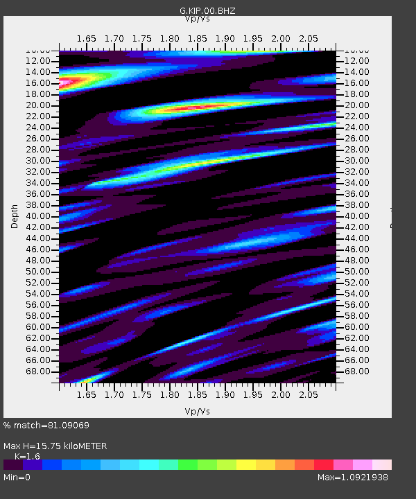
| Estimated Moho Depth: |
15.75 km |
| Estimated Crust Vp/Vs: |
1.60 |
| Assumed Crust Vp: |
4.24 km/s |
| Estimated Crust Vs: |
2.65 km/s |
| Estimated Crust Poisson's Ratio: |
0.18 |
|
| Radial Match: |
81.09069 % |
| Radial Bump: |
400 |
| Transverse Match: |
71.35528 % |
| Transverse Bump: |
400 |
| SOD ConfigId: |
26694651 |
| Insert Time: |
2022-01-12 18:35:18.980 +0000 |
| GWidth: |
2.5 |
| Max Bumps: |
400 |
| Tol: |
0.001 |
|
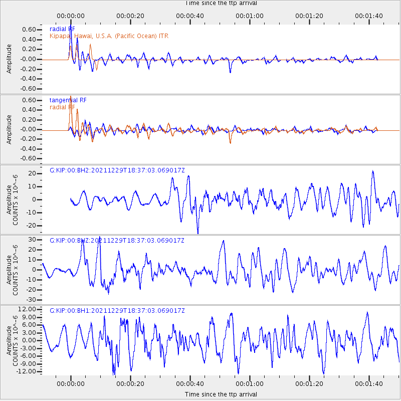
Signal To Noise
| Channel | StoN | STA | LTA |
| G:KIP:00:BHZ:20211229T18:37:03.069017Z | 2.3886771 | 1.2697233E-5 | 5.3155923E-6 |
| G:KIP:00:BH1:20211229T18:37:03.069017Z | 1.3484058 | 4.062674E-6 | 3.0129459E-6 |
| G:KIP:00:BH2:20211229T18:37:03.069017Z | 2.0199 | 7.045258E-6 | 3.4879238E-6 |
| Arrivals |
| Ps | 2.3 SECOND |
| PpPs | 9.5 SECOND |
| PsPs/PpSs | 12 SECOND |


