You are here: Home > Network List > G - GEOSCOPE Stations List
> Station SANVU Espiritu Santo, Vanuatu > Earthquake Result Viewer
SANVU Espiritu Santo, Vanuatu - Earthquake Result Viewer
| Earthquake location: |
Banda Sea |
| Earthquake latitude/longitude: |
-7.6/127.6 |
| Earthquake time(UTC): |
2021/12/29 (363) 18:25:51 GMT |
| Earthquake Depth: |
167 km |
| Earthquake Magnitude: |
7.3 mww |
| Earthquake Catalog/Contributor: |
NEIC PDE/us |
|
| Network: |
G GEOSCOPE |
| Station: |
SANVU Espiritu Santo, Vanuatu |
| Lat/Lon: |
15.45 S/167.20 E |
| Elevation: |
56 m |
|
| Distance: |
39.5 deg |
| Az: |
105.011 deg |
| Baz: |
276.814 deg |
| Ray Param: |
0.074312754 |
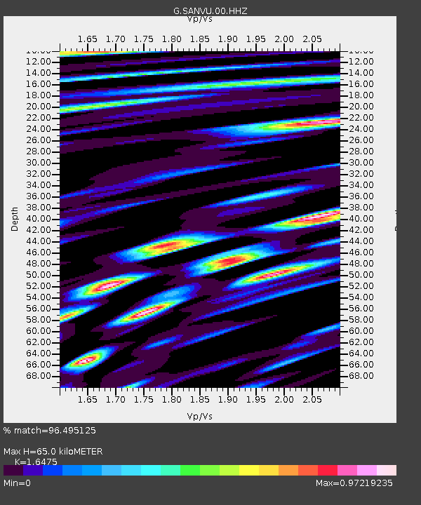
| Estimated Moho Depth: |
65.0 km |
| Estimated Crust Vp/Vs: |
1.65 |
| Assumed Crust Vp: |
4.802 km/s |
| Estimated Crust Vs: |
2.915 km/s |
| Estimated Crust Poisson's Ratio: |
0.21 |
|
| Radial Match: |
96.495125 % |
| Radial Bump: |
400 |
| Transverse Match: |
89.96688 % |
| Transverse Bump: |
400 |
| SOD ConfigId: |
26694651 |
| Insert Time: |
2022-01-12 18:35:22.159 +0000 |
| GWidth: |
2.5 |
| Max Bumps: |
400 |
| Tol: |
0.001 |
|

Signal To Noise
| Channel | StoN | STA | LTA |
| G:SANVU:00:HHZ:20211229T18:32:36.108995Z | 30.961159 | 1.5609208E-5 | 5.041545E-7 |
| G:SANVU:00:HHN:20211229T18:32:36.108995Z | 6.869219 | 1.5467518E-6 | 2.2517142E-7 |
| G:SANVU:00:HHE:20211229T18:32:36.108995Z | 26.180485 | 8.485367E-6 | 3.241104E-7 |
| Arrivals |
| Ps | 9.1 SECOND |
| PpPs | 34 SECOND |
| PsPs/PpSs | 44 SECOND |


