You are here: Home > Network List > II - Global Seismograph Network (GSN - IRIS/IDA) Stations List
> Station COCO West Island, Cocos (Keeling) Islands > Earthquake Result Viewer
COCO West Island, Cocos (Keeling) Islands - Earthquake Result Viewer
| Earthquake location: |
Banda Sea |
| Earthquake latitude/longitude: |
-7.6/127.6 |
| Earthquake time(UTC): |
2021/12/29 (363) 18:25:51 GMT |
| Earthquake Depth: |
167 km |
| Earthquake Magnitude: |
7.3 mww |
| Earthquake Catalog/Contributor: |
NEIC PDE/us |
|
| Network: |
II Global Seismograph Network (GSN - IRIS/IDA) |
| Station: |
COCO West Island, Cocos (Keeling) Islands |
| Lat/Lon: |
12.19 S/96.83 E |
| Elevation: |
1.0 m |
|
| Distance: |
30.6 deg |
| Az: |
258.941 deg |
| Baz: |
84.319 deg |
| Ray Param: |
0.07894759 |
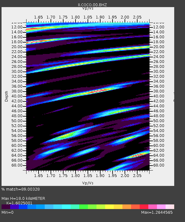
| Estimated Moho Depth: |
18.0 km |
| Estimated Crust Vp/Vs: |
1.60 |
| Assumed Crust Vp: |
4.24 km/s |
| Estimated Crust Vs: |
2.646 km/s |
| Estimated Crust Poisson's Ratio: |
0.18 |
|
| Radial Match: |
89.00328 % |
| Radial Bump: |
400 |
| Transverse Match: |
69.424736 % |
| Transverse Bump: |
400 |
| SOD ConfigId: |
26694651 |
| Insert Time: |
2022-01-12 18:36:20.384 +0000 |
| GWidth: |
2.5 |
| Max Bumps: |
400 |
| Tol: |
0.001 |
|
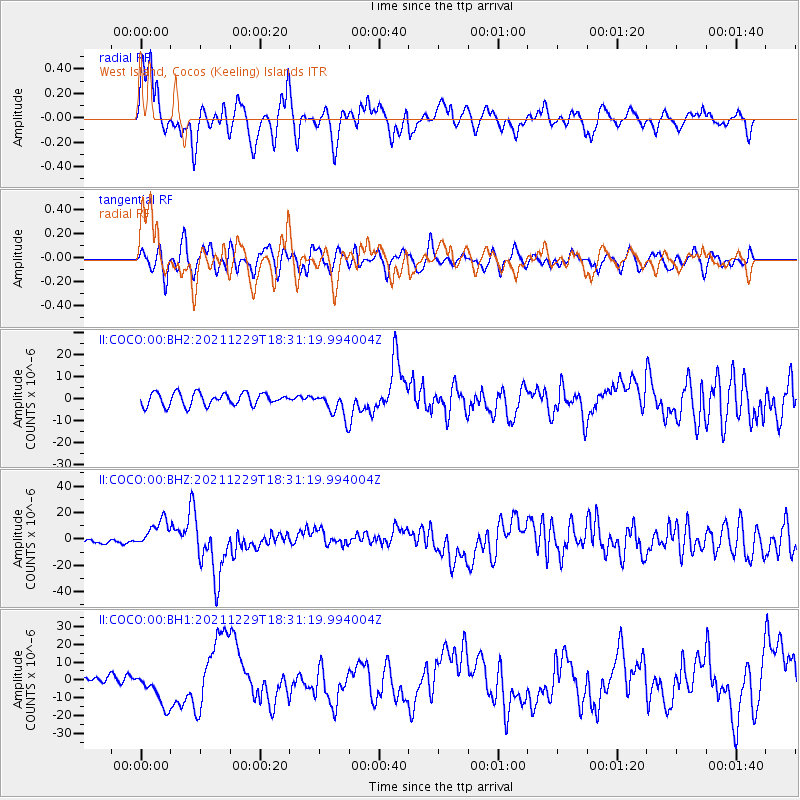
Signal To Noise
| Channel | StoN | STA | LTA |
| II:COCO:00:BHZ:20211229T18:31:19.994004Z | 6.230738 | 1.0688676E-5 | 1.7154752E-6 |
| II:COCO:00:BH1:20211229T18:31:19.994004Z | 4.567236 | 9.975879E-6 | 2.1842266E-6 |
| II:COCO:00:BH2:20211229T18:31:19.994004Z | 2.001574 | 5.703305E-6 | 2.84941E-6 |
| Arrivals |
| Ps | 2.7 SECOND |
| PpPs | 11 SECOND |
| PsPs/PpSs | 13 SECOND |


