You are here: Home > Network List > II - Global Seismograph Network (GSN - IRIS/IDA) Stations List
> Station KURK Kurchatov, Kazakhstan > Earthquake Result Viewer
KURK Kurchatov, Kazakhstan - Earthquake Result Viewer
| Earthquake location: |
Banda Sea |
| Earthquake latitude/longitude: |
-7.6/127.6 |
| Earthquake time(UTC): |
2021/12/29 (363) 18:25:51 GMT |
| Earthquake Depth: |
167 km |
| Earthquake Magnitude: |
7.3 mww |
| Earthquake Catalog/Contributor: |
NEIC PDE/us |
|
| Network: |
II Global Seismograph Network (GSN - IRIS/IDA) |
| Station: |
KURK Kurchatov, Kazakhstan |
| Lat/Lon: |
50.72 N/78.62 E |
| Elevation: |
184 m |
|
| Distance: |
71.8 deg |
| Az: |
329.684 deg |
| Baz: |
128.08 deg |
| Ray Param: |
0.053649865 |
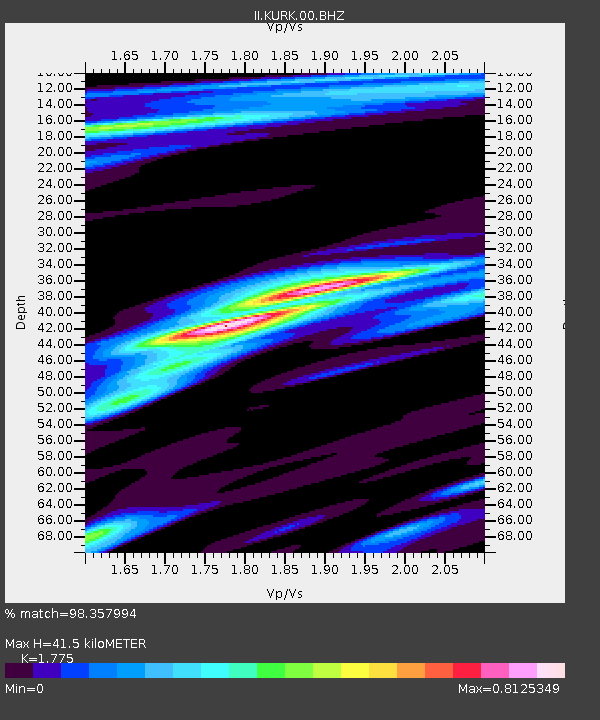
| Estimated Moho Depth: |
41.5 km |
| Estimated Crust Vp/Vs: |
1.77 |
| Assumed Crust Vp: |
6.552 km/s |
| Estimated Crust Vs: |
3.692 km/s |
| Estimated Crust Poisson's Ratio: |
0.27 |
|
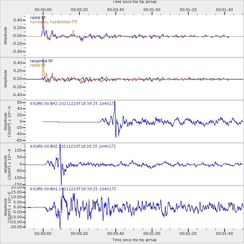
| Radial Match: |
98.357994 % |
| Radial Bump: |
307 |
| Transverse Match: |
94.52959 % |
| Transverse Bump: |
400 |
| SOD ConfigId: |
26694651 |
| Insert Time: |
2022-01-12 18:36:23.478 +0000 |
| GWidth: |
2.5 |
| Max Bumps: |
400 |
| Tol: |
0.001 |
|
Signal To Noise
| Channel | StoN | STA | LTA |
| II:KURK:00:BHZ:20211229T18:36:25.194017Z | 29.24469 | 1.2693778E-5 | 4.340541E-7 |
| II:KURK:00:BH1:20211229T18:36:25.194017Z | 7.9742513 | 1.7341331E-6 | 2.1746658E-7 |
| II:KURK:00:BH2:20211229T18:36:25.194017Z | 10.5943575 | 5.043012E-6 | 4.7600923E-7 |
| Arrivals |
| Ps | 5.1 SECOND |
| PpPs | 17 SECOND |
| PsPs/PpSs | 22 SECOND |


