You are here: Home > Network List > NK - Nepal Kathmandu (NK) Stations List
> Station KKN Kakani, Nepal > Earthquake Result Viewer
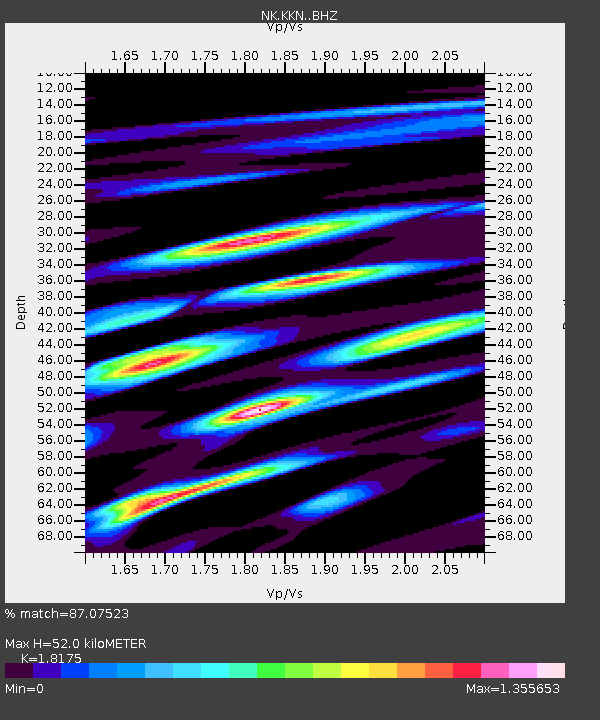
KKN Kakani, Nepal - Earthquake Result Viewer
| Earthquake location: |
Banda Sea |
| Earthquake latitude/longitude: |
-7.6/127.6 |
| Earthquake time(UTC): |
2021/12/29 (363) 18:25:51 GMT |
| Earthquake Depth: |
167 km |
| Earthquake Magnitude: |
7.3 mww |
| Earthquake Catalog/Contributor: |
NEIC PDE/us |
|
| Network: |
NK Nepal Kathmandu (NK) |
| Station: |
KKN Kakani, Nepal |
| Lat/Lon: |
27.80 N/85.28 E |
| Elevation: |
2042 m |
|
| Distance: |
53.9 deg |
| Az: |
312.478 deg |
| Baz: |
124.376 deg |
| Ray Param: |
0.06521933 |
| Estimated Moho Depth: |
52.0 km |
| Estimated Crust Vp/Vs: |
1.82 |
| Assumed Crust Vp: |
6.142 km/s |
| Estimated Crust Vs: |
3.379 km/s |
| Estimated Crust Poisson's Ratio: |
0.28 |
|
| Radial Match: |
87.07523 % |
| Radial Bump: |
400 |
| Transverse Match: |
76.93763 % |
| Transverse Bump: |
400 |
| SOD ConfigId: |
26694651 |
| Insert Time: |
2022-01-12 18:38:23.827 +0000 |
| GWidth: |
2.5 |
| Max Bumps: |
400 |
| Tol: |
0.001 |
|

Signal To Noise
| Channel | StoN | STA | LTA |
| NK:KKN: :BHZ:20211229T18:34:27.600022Z | 32.83298 | 1.0662402E-5 | 3.2474668E-7 |
| NK:KKN: :BHN:20211229T18:34:27.600022Z | 15.929556 | 3.6739436E-6 | 2.3063691E-7 |
| NK:KKN: :BHE:20211229T18:34:27.600022Z | 26.054214 | 4.365884E-6 | 1.675692E-7 |
| Arrivals |
| Ps | 7.3 SECOND |
| PpPs | 23 SECOND |
| PsPs/PpSs | 30 SECOND |


